
Weather intelligence for the future: Crafting a strategic enterprise approach to changing environmental conditions
Continue reading

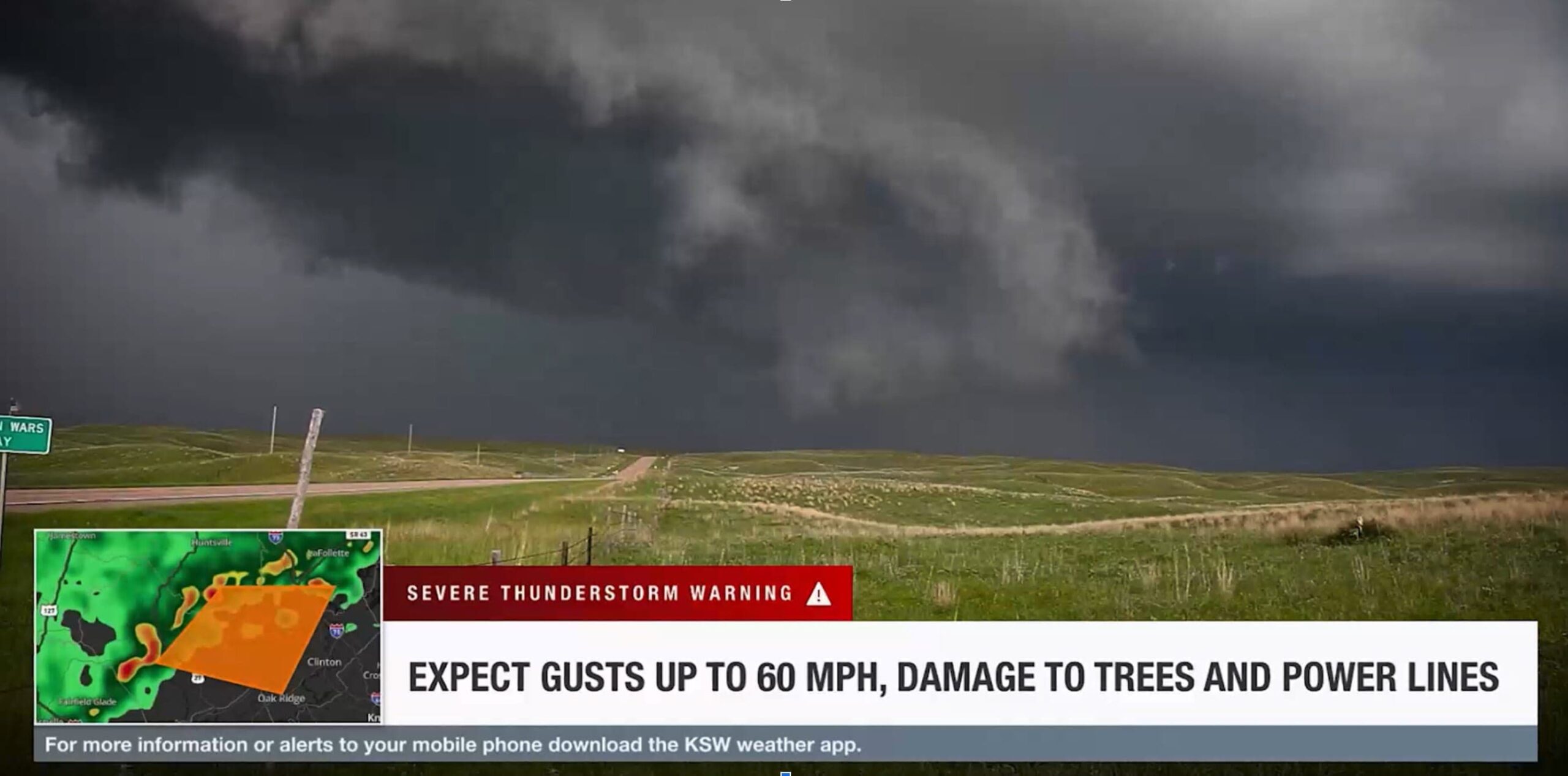
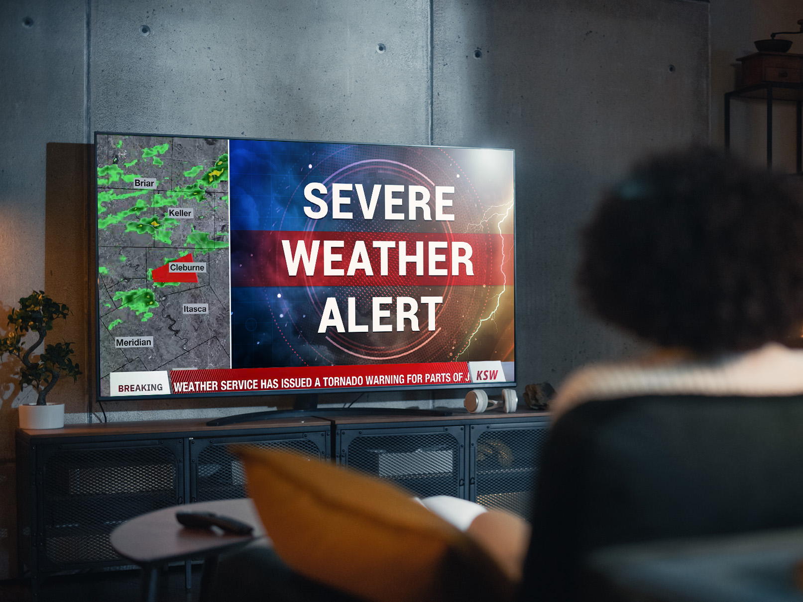
Emergency alert software plays an important role for weather broadcasters, serving as a critical tool for disseminating timely and potentially life-saving information during severe weather events.
However, not all emergency alert software is made equal. The effectiveness of these systems hinges on their design, features, and integration capabilities. To make an informed decision when choosing the best emergency alert software, it’s crucial to understand its multifaceted applications.
What is emergency alert software used for?
Emergency alert software helps bring severe weather alerts and warnings to the air. The software integrates with your existing broadcasting systems to deliver automated notifications from the National Weather Service to local audiences. These alerts can be delivered via TV broadcasts, email, text, push notifications, and a variety of other channels. According to Weather Company research done with Magid, during severe weather about 75% of viewers check their local broadcast or mobile alerts for convenient and trusted information. Thus it’s important to employ software that delivers the message to where your audience is.
Sophisticated software ensures severe weather warnings pop up on viewers’ radars in real time. Handling this manually is nearly impossible, especially with the amount of platforms requiring content and the need for repeated updates as events evolve. Emergency alert software automates severe or dangerous weather notifications, freeing up broadcasters to focus on delivering additional instructions and context. The software also supports ongoing coverage by streamlining the creation of maps and other visuals when time is of the essence.
How does emergency alert software work?
There’s a wide range of emergency alert software available, each with varying features and capabilities. However, its fundamental purpose remains the same: to rapidly communicate critical information during severe weather events.
Emergency alert software enables you to:
Design alerts
Effective emergency alert software allows you to design alerts that capture attention and deliver information clearly for TV broadcast viewers. The visual appeal of alerts is crucial, ensuring that viewers immediately grasp the severity, location, timing and nature of the weather event. Sound also plays an important role—viewers should immediately know that an important alert is occurring.
Set trigger conditions
Customizing trigger conditions is essential. Emergency alert software should enable you to set specific conditions that automatically activate alerts. Some common trigger conditions could include hazardous air quality, hurricanes, tornadoes, and landslides. Setting these triggers ensures a proactive approach, keeping your audience informed without manual intervention. Based on the severity level, these alerts can either be deployed manually or automatically. When no internet is available, these conditions should be able to trigger locally.
Test alerts regularly
Regular testing is a key component of emergency alert preparedness. Your chosen software should facilitate easy and frequent testing to ensure that alerts function as intended. This includes checking the visual elements, message delivery, and overall effectiveness.
Where can emergency weather alerts be transmitted?
Emergency weather alerts are only useful if they can reach their target destination. Being able to transmit these alerts in a timely fashion across multiple channels, such as television broadcasts and mobile app push notifications, helps ensure audiences remain aware of hazardous weather conditions.
Weather broadcasts
Emergency weather alerts are a staple of weather broadcasts. The software should seamlessly integrate with your broadcasting systems, allowing for the swift dissemination of critical information to your audience.
Mobile alerts
In an era of digital connectivity, smartphones are a primary source of information for many individuals. According to Magid, during severe weather 38% of viewers check their smartphones due to ease and speed. Ensure that your emergency alert software extends its reach to mobile alerts, maximizing the dissemination of crucial information.
OTT
More and more viewers are engaging with over-the-top (OTT) media services as a way to consume information. OTT goes beyond broadcasts, with 40% of viewers using a steaming device as a primary source for watching weather via TV according to Magid. It’s crucial to have a weather alert system that can convey emergency alert information through OTT channels.
9 features to look for in emergency alert software
Investing in emergency alert software requires a careful consideration of features to ensure optimal functionality. Without prioritizing these features, your organization can encounter unforeseen issues that prevent audiences from receiving timely weather updates when they need them most.
Let’s take a look at nine of the top features to look for when evaluating emergency alert software.
1. Automated alerts
Automated weather alerting, supported by advanced technology, is a cornerstone of effective emergency messaging software. It not only covers everyday weather forecasts but also proves invaluable during severe storms. Automated alerts are low-maintenance, ensuring accurate and up-to-date information for your broadcasts. They enhance safety, keep viewers informed, and contribute to higher engagement rates.
2. Customizable weather graphics
Visual representation is key in weather broadcasting. Look for emergency alert software that offers customizable weather graphics. These graphics should provide a clear and engaging visual representation of weather forecasts, providing viewers with detailed information about storm locations and other relevant extreme weather events.
3. Comprehensive weather map
A robust weather map feature is essential for conveying complex meteorological data to your audience. Weather map software should allow meteorologists to create, analyze, and visualize data such as distinct area maps effectively. In the case of severe weather, creating a hurricane track can serve as a supplement to details such as position, wind speed, or direction that help to keep your viewers informed on the latest status of the storm. These weather maps can also be used to display what areas should be evacuated or information on a local level. All without pre-rendering or having to employ another graphics system. An efficient emergency alert software can go beyond alerting and the standard crawl, it should be a valued asset in your toolkit.
4. Cloud capabilities
Cloud capabilities in emergency alert software are a game-changer, enabling broadcasters to create and publish high-quality videos from any location with an internet connection. This feature should also offer a streamlined interface for user-friendly navigation, facilitating easy formatting for various platforms and the creation of visually compelling graphics. This cloud-based approach also elevates the overall quality of content delivery, ensuring that critical alerts are disseminated effectively across different channels.
Cloud technology fosters real-time collaboration, allowing broadcasters and meteorologists to work seamlessly together. This collaborative environment facilitates swift decision-making and adjustments to content, ensuring that emergency alerts are visually engaging and up-to-date.
5. Simple & efficient user interface
User-friendliness is crucial in emergency alert software. A simple and efficient user interface ensures that your team can navigate the software seamlessly, reducing the learning curve and minimizing the risk of errors during live broadcasts. In critical moments, the importance of a straightforward and responsive user interface cannot be overstated, ensuring that broadcasters can focus on delivering accurate and timely information to the public.
6. Brand compatibility
Consistency is key in branding. Beyond timely alerts, the software should seamlessly integrate with your brand guidelines, ensuring that the messaging aligns with your established tone and identity. This consistent branding fosters a sense of reliability, reinforcing your viewers’ trust in the information you provide during critical moments. A focus on branding through the use of tools like broadcast templates helps present alerts in a way that resonates with your audience and reinforces the credibility of the broadcasted emergency information.
7. Language support
Language support in emergency alert software goes beyond translation; it’s about ensuring that your critical messages resonate with diverse communities. Seek software that not only offers multilingual capabilities but also considers cultural nuances, making your alerts more accessible and impactful. This inclusive approach ensures that your emergency information is understood by a broad and diverse audience.
8. Accuracy
Accurate weather forecasting is the backbone of reliable emergency alerts. Short-range and long-range forecasts should be supported, with integration with reputable sources like the National Weather Service to ensure precision. Accurate alerts help establish the credibility of your broadcast and build trust with audiences. In a study by Forecast Watch from 2017 – 2022, they found The Weather Company has the most accurate weather forecasting technology. Which ensures both timely and accurate emergency alerts.
9. Third-party data integration
Comprehensive emergency alert software goes beyond just weather alerting. It can also ingest and display third-party data within the crawl such as school closings, sports scores or headlines for added value.
Invest in custom emergency alert software with Max Alert Live
Choosing the right emergency alert software involves careful consideration of features, functionality, and integration capabilities. To keep your audience safe, consider Max Alert Live. This comprehensive solution provides customizable, automated weather alerts that can be controlled from virtually anywhere. Max Alert Live also goes beyond traditional alerting, allowing for accurate information to be displayed across platforms efficiently and effectively.
Let’s talk
To learn more about how Max Alert Live can keep your viewers safe through timely alerts and notifications, contact our media experts today.
Contact usRelated resources


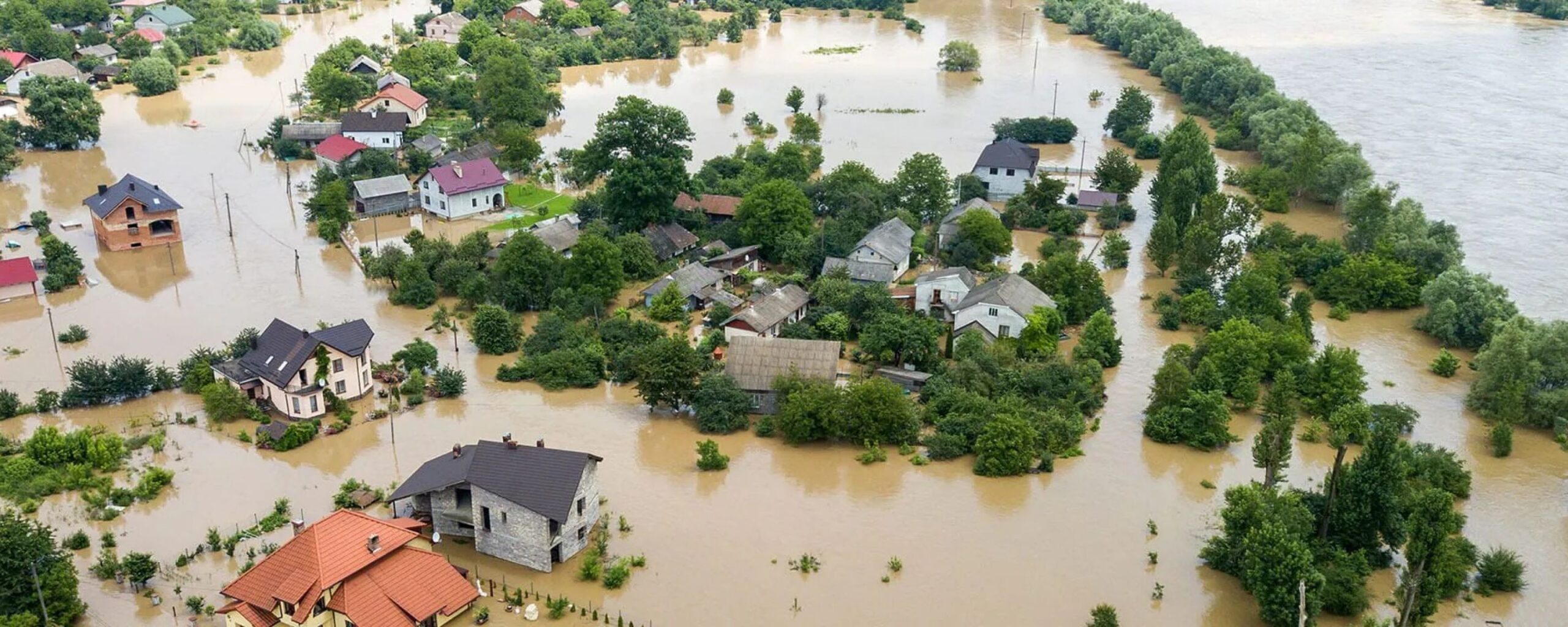
Extreme weather events pose threats to the local community. When storms form and move quickly, they can endanger human life and property, while making it difficult for broadcasters to communicate updates in real time.
Fortunately, an effective emergency weather alert system can help people stay safe. Designed to provide early notice about impending severe weather, and give people the time needed to evacuate or prepare, emergency weather alert systems can save lives and help viewers prepare for severe weather.
After understanding what they are and how they work, there are many ways for you to incorporate emergency alert systems into your broadcasts to tell a complete and accurate story.
What is an emergency weather alert system?
An emergency alert system makes it easy for broadcasters to send out real-time and automated weather information so communities can stay up to date. According to a survey conducted in cooperation with Magid and The Weather Company, viewers prefer to receive severe weather alerts across various platforms, including mobile apps (38%), local television (37%), websites (14%) and social media (12%).
As a result, organizations need to automate as much as they can to ensure that alerts are getting to their viewers. With the right solution, broadcasters can integrate data directly from the National Weather Service to create banners with lifesaving information at the bottom, top or side of television reports. High-quality weather graphics and maps should also be included as an option to provide viewers with strong visuals of affected areas.
When are emergency broadcasting systems used?
Emergency broadcasting systems are used in the event of severe storms, where damage can be expected. With climate change affecting weather patterns, it’s more important than ever for broadcasters to establish a system of updating their communities. The 2020s have broken records for billion-dollar weather events, with 2020 seeing 22 of these destructive storms and 2022 seeing 18.
What goes into an emergency weather alert?
The following components can be included in a severe weather alert:
1. Crawl messages.
The crawl message is the full text of the message, which appears as a text or a screen crawl (if the event is broadcast on TV).
2. Weather graphics and maps.
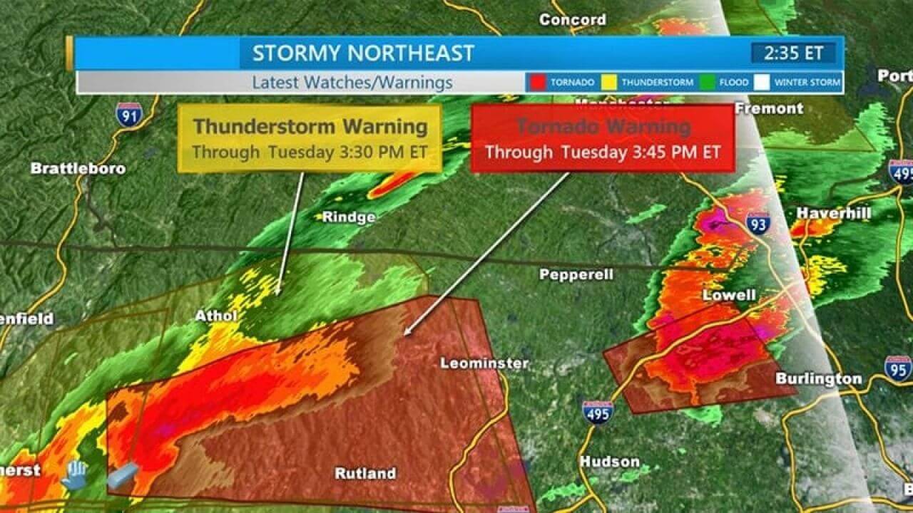
To provide accurate, real-time information for viewers, most emergency weather alerts include hazard areas that outline each area’s level of risk, depending on the nature of the impending weather event. Visuals can also help viewers assess their risk levels and better understand the data. A storm track or zoom-in on the affected DMA could also be used as well as street-level mapping.
3. Current radar.
For more detail, alerts could also include an animating current weather radar.
4. Additional weather data.
Depending on the nature of the weather event, the emergency weather alert may also include additional weather data such as the projected timeframe of the weather event or natural disaster, next steps, and agencies to contact for more resources or information.
What types of storm alerts can an emergency broadcasting system provide?
In most cases, the National Weather Service (NWS) issues Wireless Emergency Alerts (WEA) for upcoming events like tsunamis, tornados, flash floods, hurricanes, typhoons, dust storms and extreme wind events.
Here’s a detailed breakdown of different kinds of weather alerts:
1. Tornado
Tornado storm alerts come in the form of tornado watches and tornado warnings. A tornado watch advises people in the watch area to be prepared and to know that tornadoes are possible.
On the other hand, a tornado warning alerts people in the watch area that a tornado has been visually identified or confirmed on weather radar. This warning is an urgent call to take shelter on the home’s lowest floor and wait for further information or instruction.
2. Thunderstorm
A severe thunderstorm warning is issued when a thunderstorm capable of producing hail 1 inch or larger in diameter and winds of greater than 58 mph are predicted.
This warning encourages people in watch areas to seek shelter immediately since severe thunderstorms can also produce tornadoes and other weather events.
3. Hurricane
Hurricane warnings indicate that a specified area is expected to experience hurricane conditions – defined as sustained winds of 74 mph or higher.
4. Flood
Flood warnings are issued when a hazardous weather event is expected to create imminent flooding. Flood watches and advisories, however, are issued when flooding may threaten life or property or when conditions are favorable for flooding.
5. Tsunami
The National Weather Service issues tsunami warnings when tsunamis with the potential to generate flooding are expected or actively occurring. Likewise, tsunami advisories and watches caution people that tsunamis are possible and that precautions should be taken.
6. Blizzard
Blizzard warnings indicate that blizzard conditions – defined as low visibility, falling or blowing snow, and winds of 35 mph minimum – are expected for the coming three hours.
What are common issues with an emergency alert weather system?
While emergency alert weather systems are convenient and potentially lifesaving, there are some issues associated with using them.
Here are several factors that broadcasters should be aware of and cautious about:
1. Switching systems
While emergency alert weather systems should deploy rapidly, speed and reliability aren’t always a given. Instead, stations may find themselves switching between different systems to provide critical warnings.
This can create bottlenecks and operational difficulties as well as roadblocks when it comes to providing effective, accurate weather graphics that deliver to-the-minute information while maintaining a broadcaster’s branding.
2. Accuracy
Weather conditions change rapidly, and it’s essential to ensure that emergency alert weather systems are providing the most accurate, updated information possible.
Fortunately, a system like Max Alert Live integrates its data with the National Weather Service, which guarantees that weather alerts are always as accurate as possible at any given minute.
3. Speed
When a severe weather event is imminent, it’s critical to get weather alerts out as quickly as possible. Unfortunately, this can be difficult to do if a broadcaster must create and recreate weather alerts from scratch. Because of this, we recommend working with a platform that allows creators to template and trigger weather alerts, which makes for easy, fast deployment.
4. Consistent messaging
Finally, weather alerts must remain on-brand for broadcasters. Again, this is difficult to achieve if every weather alert is created from scratch. By working with an emergency alert weather system that allows for customized broadcast templates to match your brand, you can push quick, accurate, timely and on-brand weather alerts whenever you need them.
What are the benefits of choosing the right emergency alert weather system?
There are many ways in which choosing the right emergency alert weather software helps you and your broadcast network. Here are a few of the top benefits:
Keep viewers safe
Accurate emergency alert weather systems keep viewers safe while also encouraging community well-being. According to our research report with Magid, when there is severe weather, mobile apps and local TV tie for the preferred source for coverage. Local TV is driven by trust, accuracy, and hyper-local and live coverage. Viewers also noted that they want local alerts on streaming services and more detailed updates on severe weather. Communities depend on their news stations to provide accurate information and broadcasters can help viewers by investing in tools that make these updates easy to communicate.
The automation, templates and integration associated with good emergency weather alert systems allow you to go to air faster and deliver essential weather information to your viewers.
Build audience trust
Accurate emergency alert weather systems also work to promote brand loyalty. By using easy-to-understand and eye-catching graphics that correspond to your brand, you can help reassure an audience that your broadcast network is a name they can trust. By using these graphics alongside maps, your viewers can get a more complete picture of the severe weather coming their way, and better prepare.
With a service like Max Alert Live, broadcast networks can show English or Spanish text depending on the audience and use QR codes alongside a weather alert system. This allows your viewers to scan the code to learn more about the alert or warning, and what areas it is currently affecting via the station’s mobile app. It provides a more comprehensive view that has your viewers returning for the most accurate and descriptive information available.
Streamline workflow
Accuracy and speed are critical when it comes to weather alerts. Fortunately, choosing the right emergency weather alert system allows you to automate weather forecast alerts based on threat levels and risk areas, which is a great way to deliver critical information faster and more efficiently. With the right system, teams can also decide which alerts should be automated and which should be created manually based on the severity, which helps optimize the broadcast workflow.
In addition, cloud-based tools remove many of the roadblocks and bottlenecks from traditional emergency alert weather systems by making alerts easy to create and publish – no matter where you are or who is creating the content. Meteorologists can easily log in anywhere as long as they have an internet connection to create triggers to alert their community.
When severe storms hit, it’s common for internet services to be disrupted. Fortunately, you don’t need to worry about this if you’re working with a service like Max Alert Live. With this type of platform, you can trigger weather notifications locally, which helps ensure viewer safety and up-to-the-minute information, no matter what.
Create engaging and effective emergency weather alerts with Max Alert Live
Want to learn how to create engaging, effective emergency weather alerts with Max Alert Live? Follow these five smart steps:
1. Set trigger conditions beforehand
Make your alerts easy to create and publish by defining trigger conditions before you need them. Trigger conditions are the conditions under which your system will auto-generate weather alerts and send them out to your audience.
2. Customize your alerts
Again, make the most of automation. To simplify the process of sending out weather alerts, customize your alerts before it’s time to issue them. This means altering appearance, messaging and branding so that the alerts match your station branding and ensuring you’re adding relevant language, design and more.
3. Incorporate automation
Once you’ve set trigger conditions and customized your alerts, automate them so they go out without you or a member of your team having to issue them manually. This is, by far, the best way to deliver accurate, real-time weather alerts for viewers.
4. Create dynamic graphics
Weather is inherently dynamic, and your weather alerts should be, too. For best results, we recommend including maps, storm tracks, QR codes and more so viewers better understand the potential impact.
5. Match alerts with on-air appearances
Finally, use weather alerts to enhance and complement on-air appearances. This may mean including guest experts, bringing in sponsors, or running alerts in conjunction with other on-air appearances. This helps your station tell an engaging and seamless story.
Final thoughts
When it comes to keeping viewers informed, emergency weather alerts are an especially critical tool. Despite the importance of these alerts though, they can be difficult to use. Fortunately, it’s easy to overhaul your broadcasts and make them more effective by incorporating a good weather alert system into your technology stack. Max Alert Live allows you to customize, automate and integrate your weather alerts, which helps you serve your viewers, keep people safe and encourage viewer loyalty.
Related resources


Let’s talk
To learn more about our professional weather and traffic software solutions for the media industry, contact our media experts today.
Contact usHeat waves. Large storms. Droughts. Recent studies suggest that extreme weather events like these will continue happening more often and with increasing severity.
As extreme events grow in frequency and severity, where will people turn for important information?
Research from Magid and The Weather Company revealed that when severe weather strikes, 38% of people use a mobile app to get information because they see it as quick, convenient and accurate. 37% choose local TV because they view it as a trusted resource that is both more accurate and updated than other sources. Websites and social media followed with 14% and 12%, respectively.*
Best practices for severe weather
Excellence in severe weather coverage is critical for several reasons. Obviously, broadcasters have an inherent responsibility to help keep viewers safe by clearly and accurately sharing information about potentially dangerous weather.
In addition, severe weather coverage may be your best chance to gain viewers. Our study found that weather is the number one reason that people watch a local newscast. When there are no severe conditions, viewers are far more likely to use a mobile app (51%) than a local TV newscast (24%) to get weather information.
However, 50% of viewers don’t necessarily have a “preferred weathercast,” meaning that half your available audience during extreme weather is open to trying a different station.
Following these best practices can help your severe weather coverage rise above the competition and increase viewership in these moments of both responsibility and opportunity.
1. Get to air faster with automated alerts
Overcome the perception that mobile apps are quicker by being first to air with crucial and potentially life-saving information as soon as it happens.
Implement a severe-weather alerting system that automatically triggers messages across the bottom of the screen when severe weather conditions occur. However, you should also ensure that you aren’t sacrificing speed for accuracy.
2. Create easy-to-understand graphics and presentations
Our research found that viewers want simple, uncomplicated explanations about why certain weather events are happening and how conditions are changing. This includes better and easier-to-understand weather maps and graphics, especially during severe weather.
Along the same lines, survey respondents said they want weathercasts to stop using confusing presentations.
3. Focus on key insights and takeaways
Ensure that your weathercast is focused solely on what’s important to the people watching. Respondents said that they want the weathercast to help them prepare for what’s coming based on where they live.
Viewers also said they’re tired of “unnecessary chit-chat” and would instead prefer more “weather news.”
4. Keep viewers informed across channels
Severe weather is clearly a catalyst that causes many viewers to count on the local TV weathercast when they would otherwise likely get their weather information from an app.
Your station should be the source for both by creating a mobile experience that complements and extends your on-air severe weather coverage. This can include interactive features like a QR code driving viewers to get more information on their app and additional video content that features your trusted on-air personalities, takes advantage of your local expertise and maintains your station branding.
5. Enable remote accessibility
Severe weather doesn’t always happen when we’re ready. But meteorologists no longer need to be at the station to create and deliver high-quality weathercasts.
Implement remote broadcast video production tools that are based in the cloud and allow meteorologists to log in from anywhere with an internet connection to view the current situation, choose trigger conditions and control the output to viewers.
If a station goes off-air due to inclement weather or power outages, these cloud-based production tools can empower your teams—or even those at sister stations—to still provide critical updates to viewers without much interruption.
Explore Max products
Max solutions from The Weather Company are designed to help you deliver faster, more accurate and more engaging weather forecasts to viewers. Backed by data from the world’s most accurate forecaster overall,** these products can help you stand out from the competition and increase viewership during times of severe weather.
Our on-air alerting solution, Max Alert Live, enables stations to more rapidly broadcast severe weather news with customizable automated alerts. Using a direct integration with the National Weather Service, Max Alert Live automatically triggers messages that scroll across the bottom of your presentation when predetermined weather conditions occur.
This cloud-based solution also allows meteorologists to log in from virtually anywhere to view the current situation, choose trigger conditions, create graphics and decide where to send information.
For digital alerts, Max Engage automatically creates and distributes weather and traffic alerts and videos to impacted users when predetermined thresholds are met. Stations can feature your trusted on-screen talent in both audio and video content to provide relevant local context, such as how weather or traffic may affect upcoming events in the area.
Related resources
Let’s talk
To learn more about our professional weather and traffic software solutions for the media industry, contact our media experts today.
Contact us* Research conducted by Magid, commissioned by The Weather Company; online survey conducted in May 2022 of 600 weather-information consumers; results published internally.
** Global and Regional Weather Forecast Accuracy Overview, 2017-2022, ForecastWatch, commissioned by The Weather Company.
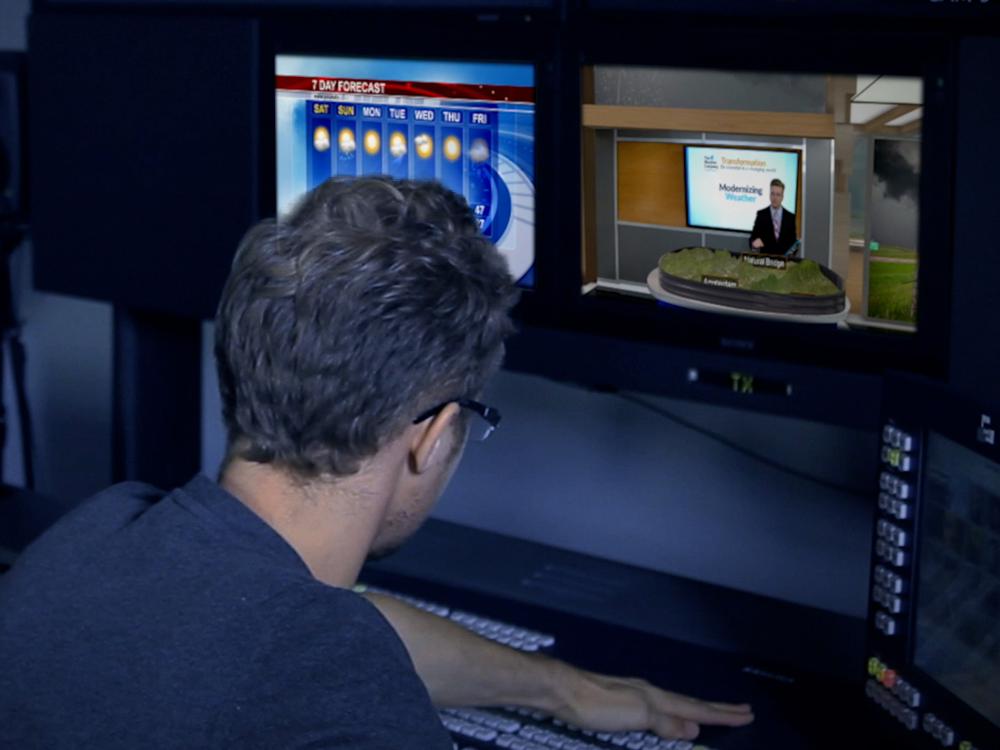
What are weather maps?
Weather maps are visual representations of meteorological data that provide insights into various aspects of weather conditions. They serve as visual aids to understand elements like temperature, pressure, wind patterns, pollen levels and more. Weather maps come in various forms, including 2D and 3D formats, enabling meteorologists to communicate complex weather patterns so viewers can make informed decisions.
What is weather map software and how does it work?
Weather map software is a specialized tool used to create, analyze and visualize meteorological data in the form of maps and charts. It helps forecasters present complex weather information in a user-friendly and visually engaging manner.
The functioning of weather map software involves several key steps. First, weather forecasting relies on numerical physics models that incorporate atmospheric conditions such as temperature variations, pressure systems, wind patterns, and precipitation levels. These models are processed through powerful computers to generate conceptual representations of potential weather scenarios. Once meteorologists review and assess these models for accuracy, they must communicate the weather to the public.
This selected model is then input into the software, where advanced algorithms and data processing techniques transform the numerical data into graphical weather maps. In essence, weather map software bridges the gap between intricate meteorological models and user-friendly visualizations.
Why is weather map software important?
By offering a clear and concise visual representation of atmospheric conditions, weather maps enable meteorologists, researchers and the general public to grasp complex data quickly and make informed decisions. For example, commuters can glance quickly at a weather map to see what precipitation they need to prepare for during their travel to work.
Moreover, weather map software directly contributes to public safety by tracking and predicting severe weather events like hurricanes, blizzards, tornadoes and thunderstorms. It empowers meteorologists and emergency responders to issue timely severe weather warnings, implement evacuation plans and minimize the impact of natural disasters.
How are weather maps used today for weather visualizations?
Weather maps stand as indispensable instruments at the forefront of meteorological communication and decision-making. Here are three examples of how they’re most commonly used in the field:
Future forecasting
Weather maps are instrumental in predicting long-term weather trends. These maps provide valuable insights that extend beyond immediate forecasts, offering individuals and businesses the ability to proactively plan for upcoming weather conditions.
Day-to-day forecasting
Weather maps play a crucial role in daily weather predictions, facilitating the process of anticipating atmospheric conditions for each day. They provide valuable insights that empower individuals to make informed decisions based on real-time weather information. By offering up-to-date forecasts, these maps assist people in planning their activities and adapting to changing weather conditions as they unfold.
Severe storms
Weather maps play a critical role in both predicting and tracking severe weather events, serving as essential tools in bolstering preparedness and safety measures. By offering insights into the development and movement of extreme weather phenomena, these maps enable timely warnings and effective emergency responses. Through their ability to highlight potential risks, weather maps contribute significantly to minimizing the impact of severe weather and safeguarding communities and infrastructure.
Components of a weather map
Weather maps are more than just a collection of data points; they serve as dynamic visual tools that convey a wealth of meteorological information. Here are the six primary components that make up weather maps:
1. Weather graphics
Weather maps incorporate visually engaging graphics that convey a range of weather-related information. These weather graphics not only provide a snapshot of current conditions, but also effectively illustrate trends such as temperature variations, wind patterns and precipitation levels. This visual representation makes meteorological data more accessible for both experts and the general public, contributing to a better understanding of complex atmospheric dynamics.
2. Landscape mapping
Landscape mapping involves overlaying data about weather conditions onto geographical landscapes, creating a visual representation that enhances the understanding of how weather phenomena interact with the physical environment. This technique integrates spatial relationships and geographical context, allowing users to observe weather patterns in relation to topography, bodies of water, and urban areas.
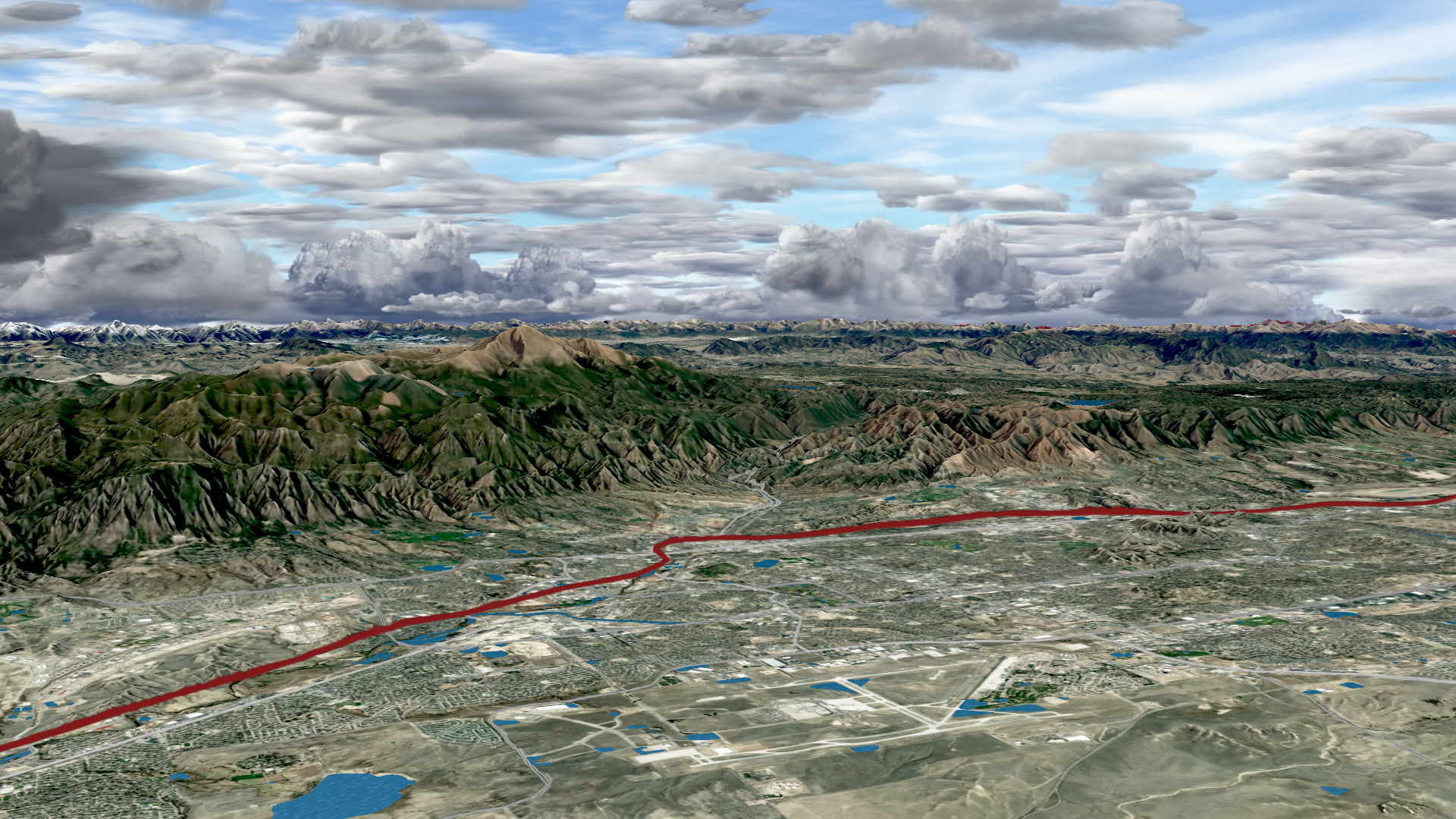
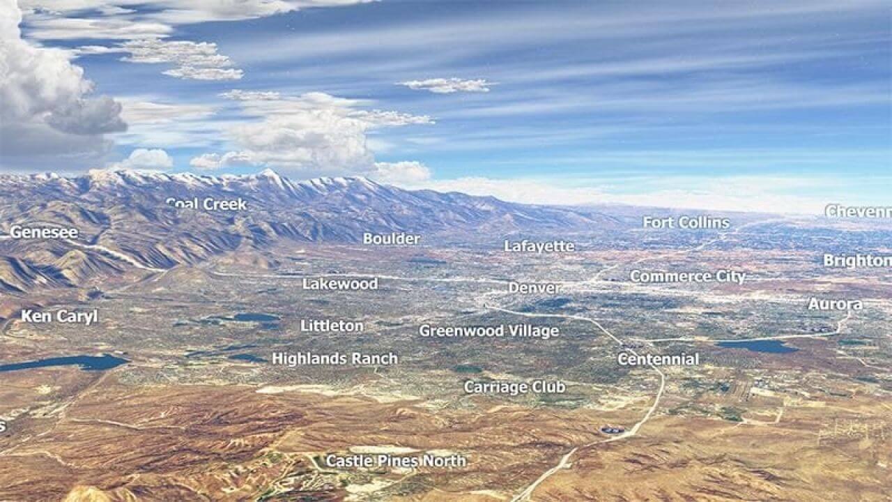
As TV screens and devices continue to deliver better resolution, it’s important for meteorologists to consider the landscapes they are using. Weather map visualization and software tools, such as MAXimum Earth, use cutting-edge rendering techniques to create more realistic animations. This tool allows meteorologists to incorporate stunning visuals of different bodies of water and mountains into their weather reports. As a result, they can offer more compelling imagery in 4K resolution.
3. Pressure areas
Pressure maps serve as critical components of weather maps, shedding light on high and low-pressure regions across geographical areas. These pressure differentials are pivotal in driving atmospheric circulation, influencing wind patterns and weather systems. By highlighting pressure gradients, weather maps provide insights into the movement and intensification of weather phenomena, facilitating more accurate forecasting and enhancing our comprehension of global atmospheric dynamics.

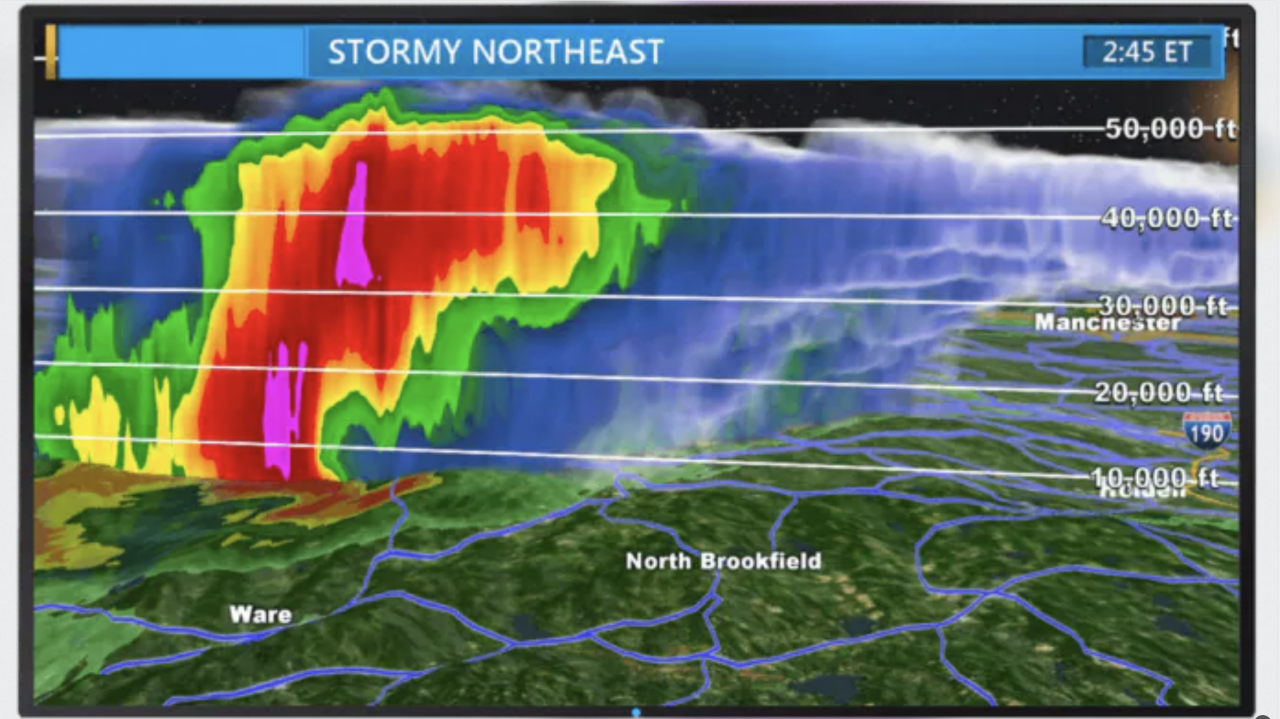
4. 3D weather radar
3D weather radar is an advanced technology that provides three-dimensional images of precipitation patterns within the atmosphere. Unlike traditional radar systems that offer two-dimensional views, The Weather Company’s Max Storm 3D weather radar captures the vertical distribution of precipitation, allowing meteorologists to analyze the intensity, altitude and movement of rain, snow and other forms of precipitation.
5. Temperature fronts
Temperature fronts delineate boundaries between air masses with different temperatures. Understanding the location and movement of these fronts is fundamental in predicting shifts in weather conditions, including not just temperature changes but also wind patterns, cloud formation and precipitation. By helping to visualize these temperature gradients, weather maps aid meteorologists in anticipating evolving weather scenarios and communicating them to the public.
6. Traffic
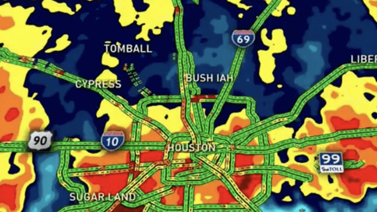
Weather maps can also incorporate traffic data, allowing users to plan routes and travel more efficiently. By understanding how real-time weather conditions interact with commute times, individuals can make informed decisions about their journeys, considering factors such as road safety, visibility and potential delays due to adverse weather. This integration of weather and traffic data enhances safety and convenience, catering to the practical needs of commuters and travelers alike.
What are the most common weather map projections?
The creation of weather maps involves projecting Earth’s spherical surface onto a flat map. This process always distorts the map to some degree, so mapmakers must choose projection methods carefully depending on where the map needs to be the most accurate. Here are three of the most common projections:
- Cylindrical projections depict the globe’s surface as if wrapped around a cylinder. This results in equal spacing of longitude lines but can cause distortion as one moves away from the equator, making them suitable for showing weather patterns over broad regions.
- Conic projections project the Earth’s surface onto an imaginary cone positioned over the North or South Pole. These projections are often used for mapping mid-latitude areas. They minimize distortion in these regions but can cause issues near the poles.
- Plane projections, also known as azimuthal projections, project the Earth’s surface onto a flat plane from a single point. These are particularly useful for depicting polar regions and maintaining accurate directions, but they exhibit distortion when portraying larger areas.
What is the most accurate weather map software?
According to ForecastWatch, The Weather Company is the world’s most accurate weather forecaster overall across regions including the US, Canada, Central America, South America, Europe, Africa, the Middle East, and Asia-Pacific, making it a globally trusted source for reliable weather information. With predictions powered by the Global High-Resolution Atmospheric Forecasting System (GRAF), The Weather Company is able to provide highly accurate weather maps displaying up-to-the-minute information.
What does the future of weather map software look like?
As technology continues to advance, the future holds the promise of even more sophisticated weather maps that have the potential to revolutionize how we perceive and understand meteorological data.
One exciting prospect is the ability to provide forecasts at a zip-code level, offering a remarkable degree of localized accuracy that caters to specific communities and neighborhoods. Additionally, advancements in data analysis, modeling techniques and the implementation of AI in weather forecasting could lead to enhanced long-term forecasting capabilities, providing individuals, industries and governments with more accurate and reliable insights into weather trends that extend further into the future than is currently possible today.
What are the current challenges of weather map software?
While weather forecasting technology has advanced considerably in recent decades, several challenges persist. The inherent complexity of atmospheric systems limits the accuracy of weather predictions. While meteorologists harness advanced numerical models and sophisticated data assimilation techniques to improve forecast precision, there are too many unknown factors to reach absolute certainty.
Moreover, it’s a challenge to tailor weather maps to a highly personalized scale. While technology enables us to provide increasingly localized forecasts, geographic limitations can get in the way of providing fully accurate information. It’s difficult to account for all the variations in topography, microclimates and urban heat islands that can affect weather across a very small area. However, as weather map software continues to evolve, it will become better and better at addressing these geographic intricacies.
Developing engaging weather visualizations with Max products
Within its suite of weather map products, The Weather Company offers a range of powerful solutions including Max Storm, MAXimum Earth, Max Traffic, Max Sky, and GRAF. Among these, MAXimum Earth stands out as an exceptional tool tailored for broadcasters and media applications. This advanced weather display software specializes in landscape mapping, seamlessly integrating meteorological data onto geographical landscapes.
Particularly advantageous for broadcasters, MAXimum Earth elevates weather visualization by offering a more immersive and contextual experience. By enhancing spatial relationships and providing real-world context, MAXimum Earth empowers broadcasters to deliver more engaging and informative weather presentations to their audiences.
Frequently asked questions
The Weather Company consistently stands out in the realm of accurate weather forecast providers and weather visualization tools. From 2017 to 2022, its prowess was recognized by ForecastWatch, earning accolades for its precision among a competitive field of 23 forecast providers. This sustained recognition underscores The Weather Company’s dedication to delivering reliable and dependable weather information to its users.
Weather maps serve as invaluable tools for meteorologists in deciphering and anticipating various atmospheric conditions. By visualizing critical factors such as precipitation, temperature fronts and wind speed, meteorologists can effectively interpret complex data. This enables them to not only comprehend the intricacies of weather changes but also to communicate these fluctuations comprehensively to the public, enhancing awareness and preparedness.
Meteorologists rely on a plethora of data sources to craft accurate and insightful weather maps. These sources include satellite observations that provide a bird’s-eye view of global atmospheric patterns and radar data which offer real-time insights into precipitation and storm movements. By harnessing these diverse data streams, meteorologists can amalgamate information from different sources to generate comprehensive and precise weather visualizations that aid understanding and decision-making.
Let’s talk
To learn more about our professional weather and traffic software solutions for the media industry, contact our media experts today.
Contact usRelated resources


1 ForecastWatch, Global and Regional Weather Forecast Accuracy Overview, 2017-2022, https://forecastwatch.com/AccuracyOverview2017-2022, commissioned by The Weather Company.
In today’s rapidly evolving media landscape, an efficient weather broadcast workflow is incredibly important. Whether you broadcast on television, radio or online, optimizing your workflow can lead to better content and increased audience engagement. In this article, we explore the concept of a broadcast workflow, its importance and provide six valuable tips to enhance it.
Let’s dive in and discover how to make your broadcasting process more efficient.
What is a broadcast workflow?
In the realm of weather forecasting, a broadcast workflow serves as a structured method for crafting and disseminating content, primarily tailored for television. This specialized workflow combines elements such as audio, video production, graphics and storytelling to weave together compelling narratives about important news stories such as weather conditions and forecasts.
Audio, video and graphics each play an integral role in this content. Audio components like spoken weather updates, meteorological explanations and ambient sounds can all enhance the viewer’s experience. Video takes center stage with live weather presenters, on-location footage, dynamic animations, real-time traffic updates and informative visuals that aid in conveying complex meteorological data. And finally, video storytelling weaves these elements into cohesive and impactful narratives, transforming raw weather information into compelling stories that resonate with viewers.
What are the types of weather broadcasting?
The world of broadcasting extends far beyond the confines of a single medium, encompassing a diverse range of practice areas, each with its unique challenges and opportunities. Weather broadcasting, in particular, stands out as a specialized domain that demands adaptability and innovation to engage and inform its audience effectively.
Here are just a few of the most common weather broadcasting practice areas:
Television
Television broadcasting remains a potent medium for delivering weather updates, news, entertainment and information to a broad and varied audience. With the advent of streaming technology and the transition to high-definition broadcasts, the quality of weather content has soared to new heights. In particular, weather broadcasting has undergone a significant transformation, aligning with the expectations of modern viewers who crave instantaneous weather information and insights.
Digital
The internet has transformed the way content is delivered, making it accessible to global audiences through websites, and mobile and social apps. Many meteorologists and other weather forecasters are already promoting their broadcasts across a variety of digital channels. Weather is an important component for station groups, who want to create more content while showing viewers stories they care about. According to Ashton Altieri of CBS4, weather plays a key role across his station group’s OTT streams and social channels.
The introduction of cloud-based platforms has further accelerated a station’s need for digital channels by offering unparalleled flexibility, enhanced collaboration and the ability to broadcast remotely. This technological shift has not only increased productivity but also empowered weather teams to tap into the best talent worldwide to tell compelling weather stories.
Radio
Radio broadcasting continues to be a popular medium, providing music, news, engaging talk shows and weather updates to a diverse and loyal audience. While radio may lack the visual components of television or digital broadcasting, it relies profoundly on audio content and skillful storytelling to engage listeners. In the realm of weather broadcasting, radio follows a similar workflow, delivering vital weather information in a format that captivates the imagination and keeps communities informed about weather conditions.
How does a broadcast workflow work?
All weather broadcasts are preceded by several stages of preparation, each of which must be handled correctly to ensure success. Weather broadcasters must seamlessly navigate these stages to meet the evolving demands of today’s viewers and maintain the high standards expected in the industry.
Planning
The planning stage is where crucial decisions are made, including the broadcast topic, duration, platform and timing. Broadcasters must select a weather topic that resonates with their viewers and listeners, considering audience interests and staying attuned to current meteorological events or trends. For example, according to Magid’s research conducted on behalf of The Weather Company in May 2022, 49% of weather consumers are very interested in hearing more health-related news. Additionally, they must carefully determine the broadcast’s duration, striking a balance between brevity for breaking weather updates and depth for comprehensive weather analysis.
Creation
During the creation phase of the weather broadcast workflow, a multifaceted process unfolds to craft compelling content. This phase involves the integration of audio, video, graphics, and storytelling, marking a fusion of creative expression, technical proficiency and collaborative teamwork. Audio production captures and manipulates sound elements relevant to the weather report, while video production focuses on visually conveying weather stories through filming, animations and graphics.
Editing
Editing serves as the bridge that skillfully merges all components of the weather broadcast. Editors play a critical role by meticulously examining and refining the raw materials, which include audio recordings, video footage, graphics and the narrative script. Their goal is to ensure that each element not only meets but surpasses quality standards. Editors then weave these elements together into a cohesive and compelling narrative package that captivates and informs the audience effectively.
Distribution
Once the weather content is created and polished, the next critical step in the broadcast workflow is distribution. This phase involves the strategic dissemination of content across various platforms. These platforms encompass traditional television broadcasts, online weather portals, and radio. The success of this distribution process relies on the implementation of effective strategies to ensure that weather updates reach their intended audience promptly and leave a meaningful impact.
What are the advantages of an efficient broadcast workflow?
Efficiency is at the core of a successful weather broadcast workflow. Without efficiency, broadcasters risk falling behind competitors and losing the trust of their audience, which ultimately prevents them from being successful.
Getting a broadcast out first
Speed is crucial in broadcasting. Being the first to provide essential information can boost ratings, demand from advertisers and revenue. Viewers expect up-to-date and reliable information alongside broadcasters who deliver this to gain a competitive edge.
A greater focus on accuracy in weather forecasting
Accurate weather forecasting is not only essential for keeping viewers informed but also for building trust and credibility. Broadcasters who provide precise weather forecasts establish themselves as reliable sources of information. Additionally, advertisers can better target their audiences based on upcoming weather conditions, enhancing their effectiveness.
Efficiency
Efficiency means reduced costs, faster content production and better resource utilization. Cloud-based production tools, such as Max Cloud, streamline video production, allowing teams to create content from anywhere, respond to breaking news quickly and collaborate effectively.
What are the current challenges of developing a broadcast workflow?
Developing an effective broadcast workflow comes with a unique set of challenges. One significant challenge is the initial hurdle of getting started. Selecting the right broadcast workflow software that aligns with your business objectives can be a daunting task. It’s crucial to find a solution that caters to the specific needs of your organization and content goals.
Another challenge lies in applying consistency across all projects. Maintaining a consistent approach to content creation can be difficult but is vital for establishing a strong brand identity and engaging your audience effectively. Overcoming this challenge often involves the establishment of clear guidelines and standards to ensure that each project aligns with your overarching objectives.
Six tips to improve the weather broadcast workflow
Now that you have a better understanding of the requirements of a broadcast workflow, let’s delve into six insightful tips that will empower you to elevate your broadcasting process. By incorporating these strategies, you can streamline your workflow, enhance the quality of your content and ensure your broadcasts are not only informative but also engaging:
1. Invest in automation
Automation plays a pivotal role in streamlining broadcast workflows, freeing up valuable time for the human-centric aspects of broadcasting. Everyday forecasting benefits significantly from automation, utilizing advanced algorithms to swiftly process meteorological data, resulting in highly accurate and up-to-date automated weather forecasts. This not only elevates the quality of weather reporting but also fosters deeper audience engagement by providing essential information promptly.
Automation can also help to send out push notifications and alerts for rapidly changing weather conditions. Severe weather alerts, automatically generated by the National Weather Service, are vital for viewer safety during extreme weather events. These alerts can take various forms, from compelling textual notifications to engaging graphics, and are designed to interrupt regular programming to convey critical, potentially life-saving information during severe weather. Automation in this context proves invaluable in rapidly disseminating vital updates to the public and helping to ensure their safety while enhancing the viewer experience.
2. Take advantage of the cloud
Cloud-based platforms offer broadcasters not only flexibility and collaboration but also the ability to work seamlessly from anywhere at any time. They enable the inclusion of subject matter experts at the click of a button, enhancing the depth and credibility of broadcasts. Monetizing content becomes effortless, with customizable video themes that seamlessly incorporate partner branding and messaging, ultimately increasing revenue streams. With more content, there are more opportunities to monetize. In addition to these benefits, cloud-based production tools reduce costs significantly, making high-quality video production accessible without the need for extensive equipment and production teams.
3. Incorporate AI into the broadcast workflow
AI technologies are transforming the broadcasting landscape by enhancing the accuracy of weather predictions, ensuring that viewers receive precise and timely information. Through content triggers such as responding to changes in temperature or humidity, AI personalizes the user experience by delivering tailored content based on individual preferences and location, increasing audience engagement and satisfaction. Automated severe weather alerts powered by AI play a vital role in keeping viewers safe by delivering real-time notifications of impending weather hazards.
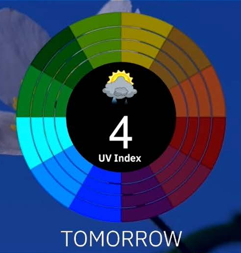
Moreover, AI weather forecasting enriches broadcasts with lifestyle context, offering viewers additional information on topics such as air quality indexes, pollen forecasts, and UV index levels, further enhancing their decision-making based on weather conditions.
4. Utilize templates
Templates are a game-changer in content creation, allowing broadcasters to maintain consistency across various projects and optimize workflow efficiency. By streamlining the process of creating essential elements like severe weather graphics, broadcast templates contribute significantly to audience retention and engagement. Not only that, but templates can be automatically resized based on distribution method, whether that be social media or for a television broadcast. These standardized tools ensure that vital information is presented in a clear and visually compelling manner, enhancing the viewer’s experience and understanding of critical content.
5. Promote collaboration among your team
In the fast-paced world of broadcasting, outdated systems can cause costly bottlenecks, impeding workflow efficiency and productivity. To stay competitive and meet the demands of modern audiences, it’s essential to invest in cutting-edge, user-friendly systems that not only accelerate content creation but also foster collaboration among team members. These advanced systems empower broadcasters to produce high-quality content swiftly, adapt to changing conditions and remain agile in delivering news and entertainment to their viewers.
In addition, tools like the cloud make it easier for station groups to leverage materials to the right person to cover a story. In cases where one station faces an outage, station groups can help cover for one another, leading to a more productive workflow.
6. Leverage high-quality images
High-quality visuals are indispensable in capturing viewers’ attention and conveying information effectively. Incorporating compelling weather map software and images not only enhance engagement but also facilitate viewers’ comprehension of complex data, such as weather patterns or geographic information. Leveraging high-quality weather graphics can set your content apart and leave a lasting impact on your audience, ensuring that your message is not only seen but also understood.
Improving weather broadcast workflows with Max products
The Weather Company’s Max products, including Max Cloud and Max Velocity, can significantly enhance your broadcast workflow.
Max Cloud is ideal for collaboration. It stores assets in the cloud, ensuring easy access for all team members. This flexibility allows teams to produce, publish and post content anytime, anywhere. This can improve productivity and allow your station to focus on creating unique and captivating content.
Max Velocity enables you to quickly create digital content with weather graphics and templates, making them more engaging and efficient. These graphics and templates can be reused without specialized skills by ideally any team member. They enhance audience engagement and help enable stations to become trusted and relevant sources of information. When used together with the entire Max suite, these products have the power to deliver powerful stories alongside stunning imagery with ease.
Ultimately, a streamlined broadcast workflow is essential for delivering top-notch content to your audience. Whether you’re in television or digital broadcasting, these tips and Max products can help you optimize your broadcast workflow, ensuring that your content is timely, engaging and efficient.
Let’s talk
To learn more about our professional weather and traffic software solutions for the media industry, contact our media experts today.
Contact usRelated resources
When it comes to delivering accurate and engaging weather information, weather stations rely on a diverse range of software applications. These applications play a pivotal role in collecting, processing and presenting accessible meteorological data to the public. In this comprehensive guide, we explore the world of weather display software and its essential functions, helping you understand its significance in modern meteorology and broadcasting.
What software do weather stations use?
Weather stations rely on a variety of software applications to fulfill their tasks effectively. These applications can be broadly categorized into three main types:
Weather analysis software: Weather analysis software is the backbone of meteorological operations. It helps meteorologists collect, process, and analyze weather data from various sources. This software aids in creating weather forecasts and understanding atmospheric conditions. It uses sophisticated mathematical models and algorithms to make sense of the vast amount of data available.
Weather communication software: Weather communication software is designed to disseminate weather information to the public, via means including television broadcasts, websites, and mobile apps. This type of software focuses on making weather data understandable and accessible to a wide audience. Weather communication software often includes features for creating visually appealing weather graphics, which are vital for keeping viewers informed and engaged. This can also include automated weather forecast updates such as severe weather alerts.
Weather display software: Weather display software combines high-quality graphics and weather mapping software with accurate weather forecast data. This software aims to create visually compelling weather presentations for both on-air and digital platforms. It serves as a bridge between complex meteorological data and the general public, making weather information more accessible and engaging.
What is weather display software used for?
Weather display software has a wide range of applications, each contributing to the effectiveness of weather reporting and forecasting. Let’s explore some key functions that empower meteorologists and broadcasters to provide crucial weather information to the public with precision and clarity:
Communicating weather updates with weather graphics
Weather graphics are indispensable tools for forecasters to effectively convey weather information to viewers. At their simplest level, these graphics use symbols like raindrops and sun icons to represent weather conditions. However, with technological advancements, meteorologists can now incorporate visual elements like augmented reality, 3D imagery, and interactive features into their broadcasts, making their segments more visually appealing and informative. By employing weather graphics, meteorologists engage audiences and provide clear, data-driven weather forecasts based on real-time data from various sources.
These graphics play a significant role in enhancing viewer engagement, fostering audience loyalty, and bolstering the credibility of meteorologists and news stations.
Weather forecasting
Weather display software aids meteorologists in producing accurate and timely weather forecasts. By visualizing complex weather data and trends, forecasters can predict changes in the atmosphere, precipitation and temperature. Accurate forecasting is vital for community preparedness, safety and decision-making.
Weather display software also often includes advanced weather mapping features. These maps provide visual representations of weather patterns, temperature variations and other meteorological data. Weather mapping enhances the overall presentation of weather forecasts and allows meteorologists to help viewers pinpoint the weather impact location. This is especially important for tornadic activity where seconds count.
Creating strong visuals with weather radar
Weather radar technology has evolved significantly over the years. 3D weather radar technology extends coverage in three dimensions, encompassing depth and elevation. This advanced capability equips newsrooms to craft comprehensive and engaging narratives that resonate with their audience. For example, Max Storm, a powerful weather display software, offers stunning 3D weather visualizations and accurate data, allowing broadcasters to engage their audience in real-time.
Showcasing traffic updates
Weather display software can also integrate with traffic data, helping commuters plan their routes effectively. By showing traffic patterns, overlaying weather data and suggesting alternate routes, broadcasters’ reports become vital for viewers, fostering loyalty and engagement. By distributing real-time traffic reports across various platforms, including social media, mobile and the web, broadcasters can expand their reach and provide valuable information to their audience.
Weather maps
Weather visualization and map software can make it easier for viewers to understand the impact of weather on their communities. Landscape mapping can help viewers comprehend how weather affects the physical environment, while 3D weather radar can further illustrate the vertical distribution of precipitation.
How to choose the right weather display software
Selecting the right weather display software for your organization is crucial for delivering accurate and engaging weather information. Consider these factors to help you align your decision with your specific weather communication and forecasting needs and objectives:
Accuracy
Selecting the right weather display software is a critical step in ensuring reliable and accurate weather forecasts. Most advanced software allows meteorologists to select and compare various forecasting models. Based on their knowledge and expertise, they then choose the one they believe to be the most accurate and tweak it as needed. What’s most important is that the software has global models, like Global High-Resolution Atmospheric Forecasting System (GRAF), that have consistently outperformed other models.
Accurate weather display software empowers meteorologists to visualize and interpret intricate weather data. By utilizing high-quality graphics and interactive features, meteorologists can engage viewers and provide clear, data-driven forecasts based on real-time data from various sources. This level of accuracy enhances viewer trust and loyalty while ensuring that communities receive timely information for making informed decisions in response to changing weather conditions.
Cloud capabilities
Cloud-based weather display software offers several advantages for broadcasters. Firstly, it enables rapid response to breaking news and weather alerts, allowing teams to collaborate on video production and publish essential information swiftly. This speed is particularly crucial in capturing viewer attention during weather reporting.
Additionally, cloud-based production tools make it possible to create videos from virtually anywhere, eliminating the need for specialized equipment and training. Broadcasting teams can produce content remotely, enhancing flexibility in news and weather reporting.
Scalability
Like your other technology tools, your weather display software should scale up with your organization. Adding new stations to your group or additional segments to your broadcasts shouldn’t be a strain on your infrastructure. Additionally, you should be able to expand into new geographies without a hassle. Look for software solutions that deliver even sophisticated outputs like augmented reality imagery with minimal latency, no matter where the software is deployed.
Ease of use
Weather display software should be easy to learn and operate. Look for software solutions that offer streamlined training and minimal complexity. Having all of your weather products under the same system simplifies operations and reduces the need for additional staff who specialize in the specific tool.
Capabilities
Consider the specific capabilities offered by weather display software. For example, Max Storm provides cutting-edge features like a new lightning counter, parameters for Significant Tornado, Significant Hail, and Supercell Composite storms, easy-changing radar moments with a single click, revamped palette displays and customizable toolbars. Assess whether these capabilities align with your organization’s needs and objectives. The right tool is also highly customizable, allowing meteorologists and broadcasters the ability to account for the weather patterns in their region and branding when displaying information.
What does the future of weather display software look like?
The future of weather display software holds the potential for even more advanced capabilities. Here are some trends and developments to watch for as this technology continues to evolve and shape the field of meteorology and weather reporting:
Broadcast templates
Broadcast templates are a standardized structure for the visual elements of a broadcast. Their adoption is on the rise in part because they enable quick adaptation to changing news and weather stories across different channels.
They’re also valuable for cross-channel content creation, catering to varying viewer preferences. By automating branding efforts and maintaining a consistent look, templates enhance brand recognition and engagement. Additionally, in the context of severe weather presentations, broadcast templates play a critical role in delivering easy-to-understand, timely and engaging severe weather graphics to inform and protect viewers.
More sophisticated weather maps
The demand for finer weather details at a more local level is on the rise. Viewers expect accurate weather forecasts tailored to their specific locations. Sophisticated weather mapping capabilities will play a crucial role in meeting this demand. These maps provide viewers with detailed information about weather conditions in their immediate vicinity, enhancing the relevance and usefulness of the forecasts.
The emphasis on accuracy will remain a top priority. Meteorologists will continue to leverage technology and data to make precise predictions. The use of AI-driven forecast models and machine learning will further improve forecasting accuracy, ensuring that viewers receive timely and reliable weather information. Ultimately, the future of weather display software is all about delivering personalized, detailed and timely weather information to help viewers plan their day.
Max platform’s weather display software capabilities
In the realm of weather display software, The Weather Company offers several standout products that cater to different needs. Let’s delve into some of these offerings:
Max Storm: Max Storm is a powerful tool designed to enhance your coverage of severe weather events. It brings a combination of striking visualizations, precise data, and streamlined weather broadcast workflows to both on-air broadcasts and digital platforms. With real-time 3D weather radar and imagery, it engages audiences with compelling mobile content and promotes live broadcasts effectively. Max Storm doesn’t stop there; it offers advanced features like the Storm Slicer and Data Scope, enabling meteorologists to create captivating 3D weather visuals and swiftly deliver critical severe weather alerts and warnings to the airwaves.
MAXimum Earth: MAXimum Earth is your gateway to comprehensive global weather data. It opens the doors for organizations to access accurate weather visualizations from around the world. Its expansive range of weather-related data empowers meteorologists to tell effective, eye-catching stories.
Max Traffic: Max Traffic seamlessly integrates weather and data into 3D traffic forecasts, aiding commuters in planning efficient routes. Broadcasters can expand their reach by distributing real-time traffic reports across various platforms, including social media, mobile apps and websites, thereby providing valuable information to their audience.
Max Sky: Max Sky delivers realistic city skyviews paired with engaging weather information. With more than 200 cloud templates, advanced particle animations and atmospheric effects, broadcasters can stand out in their local market and offer a differentiated weather presentation to their viewers.
Frequently asked questions
When it comes to accuracy in weather forecasting, The Weather Company consistently comes out on top. In 2022, The Weather Company consistently achieved over three times higher top rankings globally across all forecast lead days (1-9) than any other weather provider included in ForecastWatch’s Global and Regional Weather Forecast Accuracy Overview, commissioned by The Weather Company.
Yes, many products within The Weather Company’s Max suite are cloud-based, so they can be used from virtually anywhere at any time. This flexibility is particularly valuable for news and weather reporting teams who need to respond quickly to changing conditions.
Yes, cloud-based weather display software updates automatically, eliminating the need for manual updates. This ensures that you always have access to the latest weather data and features without interruption.
Weather reporting relies on a combination of software applications, including weather analysis software, weather communication software and weather display software. Some solutions encompass all four of these applications to collect, analyze and communicate weather information to the public effectively.
Weather stations use various software applications, including weather analysis software, weather communication software and weather display software. These applications help meteorologists collect, analyze and present weather data accurately.
Let’s talk
To learn more about our professional weather and traffic software solutions for the media industry, contact our media experts today.
Contact usRelated resources
Content reigns supreme in today’s competitive environment. Accelerating video production is becoming increasingly important in a world where networks are looking for ways to expand audiences and boost the value of their station. Cloud-based production can help stations create high-quality videos so that news and information can get to air quickly.
There are many ins and outs of cloud-based production. Read on to find out how implementing cloud tools can help your organization improve video content and reach more viewers.
Why is cloud video production important?
Cloud video production is changing the future of broadcasting. Not only is it a potential cost-reducing measure, but it also allows stations freedom in when and where videos are made.
In a highly competitive environment, standing out among rival stations has become more important than ever. Cloud tools allow stations to take viewers right into the heart of the story, while also streamlining the video production process. Overall, as stations hope to remain competitive, cloud video production will become a necessary part of a station’s toolkit in the future.
What is cloud-based production?
Cloud-based production is a unique and innovative solution that allows broadcasters to create and publish studio-level videos from virtually anywhere, at any time. The right broadcast news production tool won’t require advanced training, allowing anyone to use the solution. The solution should be browser-based, making it easy to add to an organization’s tech stack without IT or engineering support. It should also allow users to format and size videos for specific platforms while creating visually compelling graphics.
Benefits of cloud-based video production
There are numerous benefits for broadcasters looking to invest in a cloud-based video platform. These are included below:
1. Accelerate video production and respond to breaking news and weather alerts quickly.
When news breaks, teams need to move fast. The best way to grab viewer attention is to be the first to publish essential information. Fortunately, cloud-based video production tools accelerate video production and remove common roadblocks such as needing team members in a set location. Kurt Rao, CTO of TEGNA, noted that his organization was looking at how they could provide “the best consumer experience, the best customer experience, and the best employee experience.” He said that “when you apply that to the news side of the house, weather is a very critical component.” Since weather affects every aspect of our lives, this content drives engagement across all platforms. Ashton Altieri from CBS Colorado also noted that audiences averaged 30 minutes or more when consuming weather content on their OTT platforms.
However, speed is critical when providing breaking news and weather alerts. Viewers expect up-to-date and reliable information when consuming this kind of content. The right tool can help teams get to air faster through accurate weather information and pre-created templates that can be accessed via the cloud.
Another severe weather product leveraging the cloud is Max Alert Live. Its command-and-control center is in the cloud which allows you to send out severe weather alerts from anywhere with an internet connection. You can also view the current situation, choose trigger conditions and control the video output.
2. Create videos from anywhere.
Cloud-based production tools make it possible to create videos without specialized training or clunky equipment. Team members can create videos at the office, or even remotely, without the regular setbacks that other production tools have. All they need is an internet connection to connect to the cloud. Remote broadcast production tools make it easy for teams to be flexible to better report on weather or the news.
Additionally, with new channels, such as OTT, stations are required to produce more content than ever before. With a cloud-based solution, teams can create more videos from any location to engage with audiences across platforms.
3. Showcase experts.
Add more value to your broadcasts by bringing in and showcasing relevant experts at the click of a button, whether the coverage is about a traffic or weather event. All experts would need is a mobile phone or laptop and cellular service to join the conversation. Experts add more depth to your broadcast storytelling and can boost loyalty among viewers.
In today’s news cycle, misinformation is top of mind for viewers. According to one study by Deloitte, more than 70% of US consumers are concerned about “fake news”. By featuring experts, your station can continue to build credibility with viewers, while providing more value.
4. Easily monetize video content.
In addition to adding value to your broadcasts and providing more information for your viewers, cloud-based production tools allow you to feature partners and monetize your broadcasts effortlessly. Through video theme customization features, a partner logo can easily be selected and placed within the video without specialized video editing tools. For native sponsorships, partners can be brought in during relevant news stories or to feature context. For example, a local hardware store could explain shoveling best practices and feature its sale on shovels prior to a snowstorm.
5. Reduce costs.
It used to be true that creating high-quality news video production was expensive. Teams needed a video crew, specialized equipment, and a production team who could cut, edit and publish videos. With cloud-based production tools, broadcasters can reduce costs for organizations without sacrificing professionalism or quality. Teams also benefit by reducing the amount of duplication. If a station in California is covering the wildfires, other stations within that group can leverage that reporting.
6. Collaborate across stations.
Promote collaboration between stations within the same station group by encouraging cross-channel video production. Cloud-based production tools make it easy and quick to do so, without sacrificing quality or struggling with complex features. Expertise can then be leveraged more effectively across the organization, to reduce duplicate effort, while creating better stories. Meteorologists can simultaneously work together in regional workgroups or even fill in for one another as needed. Max Cloud allows for low-friction content sharing and distribution, enabling virtually any producer, designer, or -meteorologist to contribute to shows for multiple markets. This feature is especially valuable during long-duration severe weather, blizzards, or tropical events where any meteorologist can contribute scenes or coverage to the impacted market.
Kurt Rao of TEGNA noted that they are pushing to the cloud to improve collaboration between meteorologists and to increase the quality of their reporting and graphics. TEGNA has focused on this since they are “a big believer that weather brings audiences in.”
Additionally, if station groups were to go off air due to inclement weather or power outages, viewers can still receive updates without much interruption. Stories can be backed up to the cloud, so that they can still get to air.
7. Benefit from a secure environment.
Researchers found that the number of ransomware and backdoor attacks made up 38% of cyberattacks in 2022. With cloud-based solutions from The Weather Company that are deployed on the IBM Cloud, teams have greater protection against attacks, due to strict The Weather Company security protocols. While on-premises solutions may also be susceptible to data loss, The Weather Company features automated recovery features. Gartner and Forrester have also recognized IBM for delivering industry-leading governance through its cloud solution.
What are the limits of cloud video production?
The limits of cloud video production depend on what a station puts into it. In this case, cloud video production can be limited by how much a station puts into understanding the software. While most cloud products are easy to use, there’s still a new operating system to use that may take time to fully understand. However, when a team member becomes fluent in using the system, productivity and production become streamlined.
Best practices for cloud video production
Curious about how to start producing videos in the cloud? Here are a few best practices we recommend:
Simplify cloud production with easy-to-use tools
The best way to leverage cloud-based video production is to make it easy to access. While there is a time and place for high-end video production, breaking news and weather updates should be easy to produce, so they can get to air quickly. Producing these videos shouldn’t require an advanced degree or mastery of complex tools and technology.
With this in mind, look for ways to simplify the broadcast workflow with easy-to-use tools that anyone on your team can master.
Leverage templates in your videos
To enhance broadcast recognizability, videos should be consistent and visually appealing. Fortunately, good cloud-based video production tools make it easy to guarantee this by optimizing banner and color settings that you can choose from and apply to every video you create.
The best cloud-based production tools make it easy to adjust presentation settings to suit a specific video without sacrificing brand consistency. To create a new story, populate it over one of the existing broadcast templates in the tool.
In addition to ensuring recognizability, this is an effective way to eliminate frustrating roadblocks and be the first network to publish accurate breaking news.
Create dynamic content
To keep viewers engaged, it’s important to not just tell a story, but draw it out for them. Put your viewers amid the news, rather than just talking to them. This can be achieved by using graphics, 3D models and other augmented reality tools.
Producing an engaging video can help you build a relationship with your viewers, increasing viewer retention and loyalty across your newsroom.
Cloud video production case study
WVEC-TV put cloud production to the test when using the Max Ecosystem to assist their sister station, WTSP in Tampa, during Hurricane Ian. This hurricane resulted in USD 50 – 60 billion in damages and was the second-largest insured loss in the United States. Because WTSP viewers depended on weather updates to make decisions, it was important for this station to stay on air.
WVEC-TV used their Max systems to load a “streaming” workspace so that their station could have looped, streaming coverage of the hurricane if WTSP needed it. WVEC also shared several tropical graphics through the TEGNA shared locker for WTSP to use. As a result of the cloud production tools afforded by Max Cloud, meteorologists were able to collaborate between sister stations to maximize value and output, while keeping the Tampa station on-air to deliver vital updates.
Video storytelling from the cloud
If you’re looking for a way to improve your video storytelling practices, investing in cloud-based production tools is an excellent way to do it. Tools like Max Velocity, Max Cloud and Max Alert Live can help broadcast teams produce high-quality video content, send out timely alerts and create consistent, attractive content every single time, no matter who produces it or where it’s produced.
Frequently asked questions
Cloud video production uses browser-based tools in order to help stations bring their videos to the cloud. This allows professional videos to be posted from anywhere at any time.
Yes, the cloud allows videos to be stored prior to uploading, depending on the amount of space a station has.
Cloud-based video production has allowed streaming to be on the move. No longer is there a requirement to be stationary, but rather newscasts can be on the go to reflect and engage the audience watching it.
When searching for a cloud provider, it is important to find a cloud video streaming service that complies with security standards and privacy regulations. That helps ensure that your videos are secure and safe from malicious actors.
Related resources
Let’s talk
To learn more about our professional weather and traffic software solutions for the media industry, contact our media experts today
Contact usWhat is AI?
AI, or artificial intelligence, refers to the development of intelligent systems that can perform tasks requiring human-like intelligence. It encompasses various approaches, of which the most relevant for weather forecasting is machine learning.
Machine learning is a specific subset of AI that involves training algorithms to learn from data and perform specific tasks without explicit programming. It focuses on improving the accuracy and efficiency of these tasks by leveraging patterns and correlations in the data. In short, AI encompasses the broader field of creating intelligent systems, while machine learning is a specific technique within AI that enables systems to learn from data and perform specific functions without explicit programming.
How is AI used in weather forecasting?
Both weather broadcasters and viewers have greatly benefited from the integration of AI technologies, revolutionizing how predictions are made and communicated. Here are some of the most common applications of AI within the field:
Weather Prediction
Using AI for weather prediction is not a new innovation and has been in use since the 1970s. The weather models that broadcasters rely on to make accurate forecasts consist of complex algorithms run on supercomputers. Machine-learning techniques enhance these models by making them more applicable and precise.
Content Triggers
Besides traditional TV and radio broadcasts, many broadcasters today offer dedicated smartphone apps that provide up-to-the-minute weather information to viewers. One way AI helps broadcasters personalize the app experience is by enabling content triggers. A content trigger is a set of weather factors that automatically trigger an action in the app, such as sending the user a notification. For example, a broadcaster could set a trigger to send viewers safety graphics when temperatures in their area exceed a certain threshold for a certain amount of time in a day. These content triggers ensure that individuals receive timely and relevant information, enhancing their awareness and preparedness in weather-related situations.
Severe weather & weather alerts
On the forecasting side, by analyzing real-time data, AI can rapidly identify potential hazards such as lightning strikes, high winds or flash flooding. Then, in-app AI plays a crucial role in sending viewers automated severe weather alerts to keep them safe. These timely notifications enable individuals to take immediate action, seek shelter, or evacuate if necessary, minimizing the risks associated with severe weather events.
Lifestyle content
AI augments TV weather segments with lifestyle-related content, making weather updates more engaging and habitual. This includes providing broadcasters with health, wellness and scientific information that complements weather reports, such as air quality indexes, pollen forecasts and UV index levels. By integrating this additional context, AI enhances the user experience, enabling individuals to make more informed decisions about outdoor activities, health precautions and overall well-being based on the weather conditions.
Traffic reports
AI can monitor traffic flows and drive times to generate content that helps broadcasters inform viewers about traffic conditions and possible delays. This insight improves the accuracy and timeliness of traffic reports, allowing individuals to plan their commutes more effectively and make informed decisions about alternative routes or modes of transportation to avoid congestion. By leveraging AI-driven insights, broadcasters can provide up-to-date and relevant information, enhancing the overall quality of traffic reporting for viewers.
What are the benefits of using AI for weather?
Using AI in weather forecasting offers several significant benefits to the field.
Faster Weather Predictions
AI algorithms enable remarkable speed in processing vast amounts of data, resulting in faster and more immediate weather predictions. The ability to analyze extensive data sets in real time allows meteorologists and forecasters to provide timely and up-to-date information to individuals, businesses and governments. This speed is particularly crucial during rapidly evolving weather situations, such as severe storms or approaching hurricanes, where quick decisions and actions are necessary.
More Accurate Predictions
Moreover, machine learning in particular enhances the accuracy of weather forecasts. AI algorithms learn from historical and real-time data, identifying intricate patterns and correlations that might go unnoticed through traditional analysis methods. Sophisticated weather models can also account for complex weather conditions that are difficult to simulate through other means. This leads to more precise predictions, enabling individuals and organizations to make better-informed decisions based on the most accurate available information.
Enhanced Efficiency
Additionally, AI-driven automation processes bring enhanced efficiency to weather forecasting operations. By automating data processing and other tasks, AI enables meteorologists to focus more on the interpretation, analysis and communication of weather information. This shift allows experts to delve deeper into the implications and impacts of weather conditions, providing valuable insights and actionable recommendations to various stakeholders. The streamlined operations driven by AI also contribute to improved resource allocation and cost-effectiveness within weather-forecasting departments and organizations.
How does AI make weather predictions?
By analyzing extensive sets of atmospheric data, machine-learning algorithms extract valuable insights, identify hidden patterns and optimize meteorological models for improved performance. A lot of this information is provided by government agencies, such as The National Weather Service, in the US. However, all of these weather models are slightly different and can showcase a range of what could happen across the globe.
Global High-Resolution Atmospheric Forecasting System (GRAF), an advanced forecasting model, demonstrates the application of AI optimization techniques. Designed to generate highly accurate short-term weather forecasts, GRAF incorporates extensive atmospheric observations and employs machine-learning techniques to refine and optimize models. GRAF updates every hour and is the first weather model to run on a GPU-accelerated supercomputer. As a result, GRAF can run 5-6x faster, providing a more-accurate weather forecast.
By strategically utilizing AI and optimization methods, GRAF and similar models distill multiple weather model opinions and leverage vast amounts of observational data to provide the most-accurate forecasts possible.
How accurately can AI predict weather?
Due to the butterfly effect, it’s impossible to know how minute events can affect complex systems. In 1972, mathematician and meteorologist, Edward Lorenz, asked the infamous question, “Does the flap of a butterfly’s wings in Brazil set off a tornado in Texas?” Through this observation, he reiterated that scientists can’t currently measure the consequences of small events on the atmosphere. Since meteorologists don’t know the location of each particle in the atmosphere, there is always room for error in weather forecasting. However, AI makes it possible to make reliable weather predictions, despite these challenges.
By enabling the use of complex weather models that take in vast quantities of data, AI generally enables meteorologists to make much more accurate forecasts than they otherwise could. The accuracy of AI weather prediction depends on various factors, including the quality and quantity of data available, the sophistication of the AI model, and the specific weather phenomenon being predicted. For example, as in any weather forecast, short-term AI-powered predictions (up to a few days) tend to be more accurate than long-term ones (weeks or months). And because AI tools often rely on finding patterns in historical data, it remains difficult for them to predict rare or extreme weather events that don’t follow previous trends.
However, when combining AI and machine learning with human expertise, The Weather Company was found to be three times more likely to be the most accurate forecaster compared to other weather providers.1
What are the current challenges of AI in weather prediction?
Despite the significant benefits of AI in weather prediction, several challenges need to be addressed. One of the fundamental challenges is the inherent complexity of weather systems, which makes achieving 100% accuracy an unattainable goal. Weather patterns are influenced by numerous interconnected factors, including atmospheric conditions, geographic features and chaotic behavior, making precise predictions a daunting task.
Furthermore, the full potential of AI in weather prediction may not be realized if some weather stations and forecasting institutions are not fully equipped or capable of leveraging AI-driven insights. Effective integration of AI technologies requires infrastructure, resources and expertise to collect, analyze and interpret vast amounts of weather data. It is crucial for weather forecasting organizations to invest in AI capabilities and ensure that the necessary training and tools are available to meteorologists and forecasters to harness the power of AI effectively.
Where do humans fit in with AI weather prediction?
While AI plays a vital role in improving the accuracy and efficiency of weather prediction, humans remain essential for interpreting and communicating weather information effectively. Human meteorologists possess the expertise to transform numerical weather data into meaningful insights and outcomes that people can understand, empowering them to make informed decisions. For example, if an AI algorithm predicts heavy snowfall from an upcoming blizzard, the meteorologist can explain how it will affect traffic and commuters’ journeys the following morning. Modern weather broadcasts that combine AI-driven forecast accuracy with personalized, human storytelling make a significant positive impact on viewers’ daily lives.
Incorporating AI weather forecasting with Max products
The Weather Company’s Max products, including Max Storm and Max Velocity, integrate multiple weather models that leverage AI algorithms, so users can distill a vast array of opinions to deliver the best possible forecast.
GRAF, The Weather Company’s proprietary model, further complements these efforts by utilizing current atmospheric data and machine-learning algorithms to provide accurate short-term weather predictions. Together, these advancements demonstrate The Weather Company’s commitment to using AI and advanced modeling techniques to deliver reliable and actionable weather information. Contact The Weather Company today to learn more about their innovative, AI-driven weather forecasting solutions.
Frequently Asked Questions About AI
AI has been used since the 1970s to help predict the weather. By running complex algorithms on supercomputers, machine learning can better predict the weather forecast. Artificial intelligence is a valuable tool in making weather forecasting more accurate.
The Weather Company’s combination of AI and human expertise yields the most accurate forecast provider most often in each region compared, including the US, Canada, Central America, South America, Europe, Africa, Middle East and Asia-Pacific.2 The Weather Company uses AI to integrate input from nearly 100 forecast models around the world, weighing factors from each model based on geography, time, weather type and recent forecast accuracy.
AI in broadcast is a tool that can help meteorologists become more efficient but is not designed to replace them. Humans are still much better at deriving insights from the data that will be valuable to their viewers and offering local context (e.g. how weather may affect today’s town parade). Additionally, meteorologists excel at storytelling and continue to be the brand for many stations.
Let’s talk
To learn more about our professional weather and traffic software solutions for the media industry, contact our media experts today.
Contact usRelated resources
1 The Weather Company’s global percent of top rankings averaged over all forecast lead days (1-9) during 2022 was over three times higher than any other weather provider studied. Derived by The Weather Company using data from: ForecastWatch, Global and Regional Weather Forecast Accuracy Overview, 2017-2022, https://forecastwatch.com/AccuracyOverview2017-2022, commissioned by The Weather Company.
2 The Weather Company had the highest percentage of first-place finishes over the study period and averaged over all forecast lead days (1-9) in each region studied, according to ForecastWatch, Global and Regional Weather Forecast Accuracy Overview, 2017-2022 (pg 21), https://forecastwatch.com/AccuracyOverview2017-2022, commissioned by The Weather Company.