Weather intelligence for the future: Crafting a strategic enterprise approach to changing environmental conditions
Continue readingKey Takeaway
- Accurate forecasting of volcanic ash is vital, as it can cause severe engine damage and operational disruptions in aviation.
- The Weather Company offers real-time, global volcanic ash advisory forecasts to help airlines proactively plan routes to avoid hazardous airspace.
- Advanced tools such as RGB satellite imagery and webcams enable precise tracking of volcanic ash, enabling safer flight operations.
- Impact reports from The Weather Company enhance situational awareness for airports near active volcanoes and help minimize the risk of disruptions.
- The Weather Company’s unique tools, such as the Enroute Hazards package and enhanced SIGMETs, provide airlines with advanced insights to avoid hazardous airspace and maintain safe operations.
Volcanic ash is a hazard that can turn a routine flight into a risky endeavor, damaging engines, blinding pilots, grounding entire fleets, and endangering passenger safety. For airlines, the stakes are high, making the need for accurate forecasting, including volcanic ash, extremely critical. With industry-leading tools that go beyond standard advisories, such as the Enroute Hazards package and enhanced volcanic ash SIGMETs, The Weather Company’s forecast solutions provide aviation leaders with real-time insights to help outmaneuver ash clouds, keep flights on track, and greatly improve safety for passengers and crew.
The operational risks of volcanic ash
An aviation mechanic working on a plane engine in a hangar

Volcanic ash can cause severe damage to aircraft engines, leading to potentially dangerous situations mid-flight. The ash particles are highly abrasive and can melt in the engine’s combustion chambers, creating blockages that can lead to engine failure. In addition to engine damage, volcanic ash can interfere with navigation systems, obstruct windshields, and drastically reduce visibility, thereby elevating the risk of flying through affected airspace.
These risks often force airlines to reroute flights, delay departures, or even cancel operations, leading to costly disruptions and logistical headaches. As ash clouds move through the atmosphere, operational leaders need precise, timely information to make quick decisions and avoid unnecessary impacts on both passengers and airline schedules.
Comprehensive forecasting for aviation safety
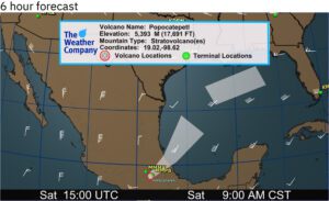
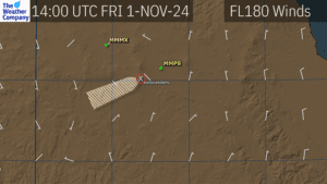
Volcanic Ash forecast Flight Plan Guidance (FPGs) display
Volcanic Ash forecast Flight Plan Guidance (FPGs) display where volcanic ash is expected to track over a period of time based on FL winds representative of the ash height. This assumes volcanic ash concentrations are high enough that ash will not become diffuse as it traverses the airspace. For forecasts extending directly from a summit, this assumes new emissions will continue.
Volcanic Ash forecast Flight Plan Guidance (FPGs) display.
To address these challenges, The Weather Company offers industry-leading tools, such as the Enroute Hazards package, designed to enhance volcanic ash and aviation safety for aviation customers of all sizes. Beyond the basic Volcanic Ash Advisory Center (VAAC) bulletins, our services include enhanced volcanic ash SIGMET (Significant Meteorological Information) notifications, which are triggered when ash reaches key thresholds: 6,000 feet above the volcano’s summit or 10,000 feet above ground, and extends over 50 nautical miles. SIGMETs are also issued for added safety if ash is detected near customer destinations, even if it doesn’t meet these thresholds.
Real-time monitoring and advanced tools
Monitoring volcanic ash in real-time is complex, but The Weather Company offers robust tools for precise tracking. RGB satellite imagery, generated from GOES-East and GOES-West satellites, enables accurate identification and monitoring of volcanic ash in the atmosphere, even under complex weather conditions. By employing techniques like channel differencing with the ash-sensitive 8.4-micron channel, this imagery allows forecasters to confidently differentiate ash from other elements like steam or water vapor.
To further refine these forecasts, The Weather Company leverages third-party webcams to visually monitor volcanic activity in real time. These webcams provide continuous views of volcanoes like Popocatépetl in Mexico, which allow forecasters to distinguish between ash emissions and less threatening emissions like steam or gas. When combined with satellite data, this real-time monitoring enables assessments of volcanic activity, improving decision-making by airline operations teams.
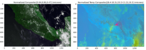
RGB imagery enhances satellite data to highlight atmospheric particulates. Using channels sensitive to volcanic ash (8.4 µm) helps forecasters identify affected areas.
Ash forecast modeling
For larger eruptions, The Weather Company uses sophisticated ash forecast modeling to predict how ash will disperse through the atmosphere. These forecasts are generated using GFS-based weather models that account for jet streams and other atmospheric factors to predict how ash clouds will move and interact with flight paths. This type of modeling is crucial for larger eruptions, during which ash can linger in the atmosphere for days or even weeks, posing a prolonged risk to aviation.
For minor ash emissions, existing ash movement patterns support decision-making. For larger eruptions, forecasts of ash dispersion provide airlines with critical information on ash location and projected movement, helping them to plan effectively for immediate and long-term impacts.
Potential volcanic ash impact reports
Potential Volcanic Ash Impact Report tracks daily volcanic ash movement, aiding aviation planning near active volcanoes.
Daily aviation volcanic ash reports are another critical component of our service, particularly for airports located near active volcanoes. Airports like those near Popocatépetl, Fuego, and Sangay receive continuous updates on the potential movement of ash toward key airspace and terminals. While these reports don’t predict explosive events, they do provide detailed insights into how current volcanic emissions might affect nearby operations.
These reports are invaluable for situational awareness, especially for airports that operate under the constant risk of volcanic activity. By offering advanced notice of potential ash impacts, airports and airlines can make proactive adjustments, reducing the risk of unexpected disruptions.
Human-over-the-loop reports for comprehensive insights
Navigate volcanic ash hazards with confidence using The Weather Company’s detailed Human-Over-the-Loop (HOTL) Reports. These reports compile relevant volcanic ash data into easy-to-read PDFs, featuring essential information such as SIGMETs, wind barbs, and satellite imagery. With this consolidated data, airlines gain a comprehensive understanding of the current situation, enabling more informed decisions on flight safety and route planning.
The HOTL reports put all relevant information in one place, offering a comprehensive picture of volcanic activity in real time. Operational leaders can take immediate, decisive action to adjust flight operations, minimizing risks and keeping passengers and crew safe.
Staying ahead with proactive volcanic ash forecasting
Volcanic ash presents significant risks to aviation, but these challenges can be effectively managed through proactive planning and real-time insights. The Weather Company’s suite of solutions helps airlines stay ahead of disruptions, empowering decision-makers to maintain safe, efficient operations, even in volatile conditions. And, because forecasting services from The Weather Company seamlessly integrate into current operational workflows, airlines can start taking advantage of this critical technology with minimal effort.
Don’t let volcanic ash cloud your operations. Elevate your airline’s safety and efficiency with The Weather Company’s industry-leading Weather Forecast Services.
Let's talk
To learn more about our advanced aviation weather solutions, contact our aviation experts today.
Contact us
