Weather intelligence for the future: Crafting a strategic enterprise approach to changing environmental conditions
Continue readingGarden variety or so called “pop-up” thunderstorms are common during the warm season and generally have limited impacts to airline operations. But there’s another kind of summer storm plaguing the airline industry that’s not so innocent: training thunderstorms. What exactly are these severe storms, what impact can they have on airline operations, and how can airline decision makers ensure they’re prepared? Read on.
What are training thunderstorms?
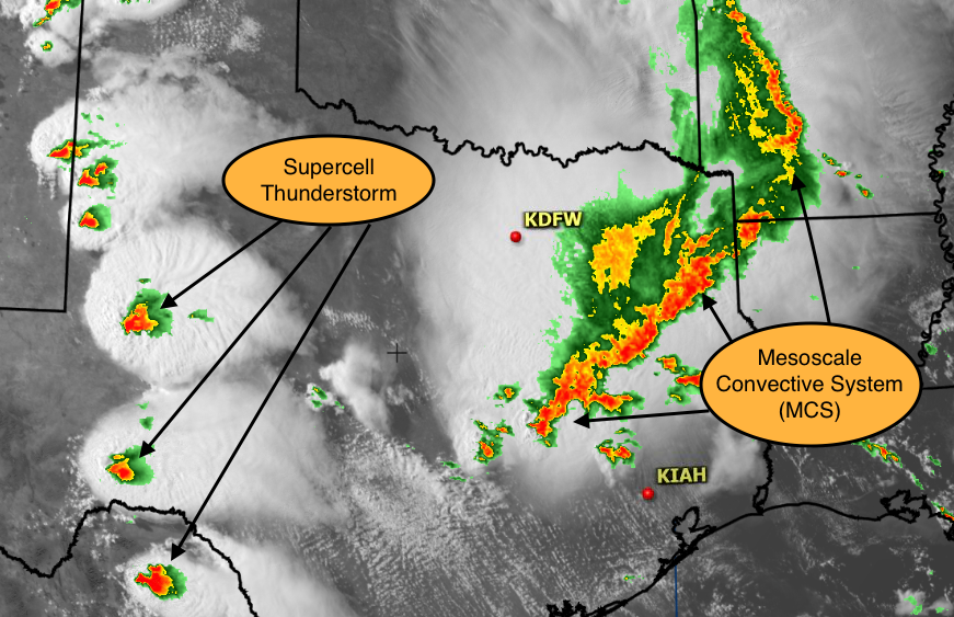
Training thunderstorms occur when a series of individual thunderstorm cells repeatedly propagate over the same geographical area. The overall collection of convective cells associated with training thunderstorms is also known as a Mesoscale Convective System (MCS). While the term “MCS” can apply broadly to any cluster of thunderstorms, a training MCS can result in a prolonged period of torrential rainfall, leading to significant flash flooding. These unique and rather rare convective systems are most common during the summer months across the central United States, occurring most frequently during the late evening and overnight hours.

Thunderstorms erupting across Texas during a hot summer afternoon, causing numerous flight diversions.
Critical to the formation of training MCSs is the presence of a slow moving surface boundary. Commonly a warm front, this boundary is crucial in generating lift to initiate the development of thunderstorms. Once thunderstorms have become established, the slow movement of this boundary can enable several rounds of thunderstorms to traverse the same areas repeatedly.
Further enhancing the likelihood of training thunderstorms is the presence of a low level jet (LLJ). This strong belt of winds in the lower atmosphere aids in transporting the large quantities of atmospheric moisture needed to sustain multiple rounds of thunderstorms.
Forecasting training thunderstorms
While certain large-scale atmospheric features can be forecasted with a relatively high degree of accuracy up to several days in advance, finer-scale atmospheric phenomena such as training thunderstorms are much more difficult to predict. In these more nuanced situations, our team of The Weather Company meteorologists leverage a suite of short-term, high-resolution forecast models to better assess atmospheric conditions. Supplementing this model data is our extensive experience forecasting past thunderstorm events, with pattern recognition serving as an invaluable tool in the accurate and timely prediction of disruptive thunderstorm events.
How training thunderstorms disrupt airline operations
As thunderstorms redevelop and repeatedly rumble overhead or in close proximity to an airline’s hub during peak arrival or departure times, the risk of significant operational disruption increases:
- Training thunderstorms over arrival fixes or the airport can lead to airborne holding and possible aircraft diversions when fuel gets low.
- Blocked departure corridors can lead to long delays on the ground as planes become stacked up nose to tail on taxiways while waiting to depart.
- Lightning over the airfield can trigger ramp closures for ground workers which can lead to suspension of aircraft boarding, deplaning, catering operations, baggage transport, and fueling.
All this leads to departure delays and possible gridlock as arriving flights wait for gates occupied by delayed departures. As diversions and delays compound, the risk of cancellations increases. Passengers are left stranded at the airport with little to do but post unfavorable comments on social media followed by negative headlines in the press. Local roadway flooding is also possible which may make getting to and from the airport challenging for passengers and employees. An airline caught by surprise may take days to recover in the aftermath of the worst events.
How The Weather Company helps airlines navigate training thunderstorms
The Weather Company meteorologists embedded within an airlines’ operations center strive to identify and communicate the risk of training thunderstorm events up to a day in advance. The goal is to give the airline ample lead time to develop an operational plan to best manage the event based on the potential start time and duration. A thunderstorm planning outlook is issued the day prior to open a dialogue with airlines’ decision makers. Subsequent forecast updates and tactical communication continue throughout the event until the risk has extinguished.
Summary
Although we as The Weather Company forecasters can’t control the weather, we do work diligently to alert airline decision makers to the potential of a training thunderstorm event. We work side-by-side with them throughout the event to provide the most accurate weather and help the airline weather the storm.
Let’s talk
To learn more about our advanced aviation weather solutions, contact our aviation experts today.
Contact us


