
Weather intelligence for the future: Crafting a strategic enterprise approach to changing environmental conditions
Continue reading


- WeatherverseTM TAK (launching in 2025) provides ATAK weather intelligence by delivering full-fidelity radar data with minimal bandwidth usage, supporting real-time decision making in low-connectivity environments.
- The ATAK weather plug-in enables future radar playback and offline weather access for military operations.
- Reliable and accurate military weather forecasting improves operational efficiency, helping teams anticipate and adapt to critical weather conditions.
Accurate, real-time weather intelligence can make the difference between success and failure in military operations. In the field, however, network connectivity is often weak or nonexistent, making it difficult to access critical weather data when it’s needed most.
Traditional radar playback struggles in low-bandwidth environments, leaving military teams without the insights required for rapid, informed decision making. To solve this challenge, The Weather Company has introduced Weatherverse TAK. Designed for multi-domain operations, the ATAK weather plug-in supports land, air, and sea missions with tailored data and mission-specific visualizations.
Unlike conventional radar solutions that degrade quality to conserve bandwidth, Weatherverse TAK uses compact tiler technology. This preserves full-fidelity weather data while substantially reducing the amount of data required. The result: Even in the most remote or resource-limited locations, military teams can access actionable weather intelligence from the world’s most accurate forecaster.1 In fact, The Weather Company is 3x more likely to be accurate than any other weather provider.2 This solution is powered by a Global High-Resolution Atmospheric Forecasting (GRAF) system, providing hourly updates at unprecedented 3-4 km resolution — a substantial advantage that helps teams improve decision making and outcomes in the field.
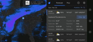
High-resolution radar data and hourly forecast details, including visibility, and more
Field obstacles: Weather data in low-bandwidth environments
Military teams often rely on weak LTE 4G signals, satellite uplinks, or mesh networks. Under these conditions, downloading radar tiles can take minutes – or fail altogether – compromising situational awareness. Recognizing these challenges, The Weather Company has spent years refining strategies to optimize data delivery for low-bandwidth environments, including:
- Progressive frame delivery: Initial radar data loads in increments, starting with every fourth frame and filling in additional frames as bandwidth allows.
- Weather tile compression: Reduces data size while preserving key weather insights.
An even more advanced solution was needed – one that could provide seamless, high-resolution weather data regardless of bandwidth limitations.
The solution: High-fidelity weather data for situational awareness
Compact tiler technology within Weatherverse TAK is a breakthrough innovation. It delivers weather dataset downloads in their entirety — with every detail retained — while minimizing bandwidth usage and file size.
Key benefits of Weatherverse TAK include:
- Efficient data transfer: Each pixel is packed with maximum data density, enabling weather dataset downloads that are faster and more comprehensive.
- Optimized performance: Advanced weather API calls streamline access to critical information.
- Robust mesh network compatibility: Delivers reliable performance even in disconnected or peer-to-peer communication environments.
- Versatile application: Works across multiple weather layers, including radar, satellite, and atmospheric models.
- Specialized weather intel kits: Contains only the data and tools needed for specific mission roles.
Field teams gain access to weather intelligence previously unavailable in low-bandwidth conditions with these capabilities. This improved weather data enhances both operational planning and on-the-ground decision making.
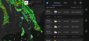
High-resolution hourly forecast radar feature
Weatherverse TAK: Turning weather data into tactical advantage
Speed and accuracy are essential in military operations, and weather conditions can shift rapidly. Having access to real-time and future weather insights enables teams to act quickly and strategically.
For example, an infantry unit preparing to launch a drone encounters unexpected rain. Since the drone is being tracked on the ATAK map, users can view with a single tap weather and radar data for the drone’s location and route, including relevant data at various altitudes.
A quick glance at the radar loop, powered by Weatherverse TAK, reveals whether the rain is a passing shower or part of a larger system. If it’s the latter, the team can adjust the drone’s flight path to avoid critical weather conditions that could impact performance.
By improving real-time weather awareness, Weatherverse TAK helps decision making happen closer to the moment of action, enabling increased operational efficiency and mission success.
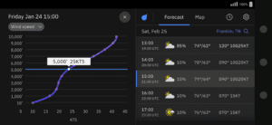
Vertical profile featuring wind speed and hourly forecast
Offline weather insights with Weatherverse TAK
When network connections are unavailable, the ATAK weather plug-in provides a crucial advantage: the ability to capture and store weather data for offline use. This feature helps teams access critical forecasts and radar data even when disconnected from a network. Here’s how it works:
- Data capture: While connected (e.g., at base), teams can download a military weather forecast, including future radar data.
- Offline playback: In the field, teams can replay hours or days of pre-synced radar loops to assess developing conditions and adjust plans accordingly.
- Proprietary data compression: Algorithms support weather data delivery in low-bandwidth environments.
Live weather data is always preferable for operations. However, this offline capability enables mission-critical insights to remain accessible even in communication-degraded environments.
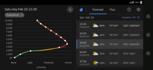
Vertical profile featuring turbulence details and hourly forecast
A new era of military weather decision making
Launching in 2025, Weatherverse TAK will be available in phone and tablet form factors, with the ability to display and present data on Windows desktop or laptop devices, delivering:
- Reliability: Provides continuous access to vital weather intelligence, even in remote locations with low-bandwidth connectivity or complete network loss. With offline capabilities, military teams can make informed decisions anytime, anywhere.
- Unmatched accuracy: Powered by forecasting models from The Weather Company, the world’s leading weather provider,3 this system delivers weather predictions that are three times more likely to be correct than the nearest competitor, providing greater confidence in mission planning.4
- Long-range forecasting: Offers an extensive view of upcoming conditions with future radar playback and a detailed 15-day forecast. This long-term insight enables proactive planning, minimizing operational disruptions due to weather.
Weather is an unpredictable force, but with the right tools, military teams can turn uncertainty into strategic advantage. The Weather Company’s Weatherverse TAK is designed to keep forces informed, prepared, and ahead of the storm.
Let's talk
To enable real-time decision making in low-bandwidth military environments, request a demo or trial of Weatherverse™ TAK today.
Contact us1 2 4 ForecastWatch, Global and Regional Weather Forecast Accuracy Overview, 2017-2022, commissioned by The Weather Company
3 According to Top Downloadable Weather Apps in 2024, by Active Users, from Sensor Tower (Jan. 1 – Dec. 31, 2024)